


Aircraft and Other Platform Data : Deepwater Horizon Support
Airborne eXpendable BathyThermograph (AXBT) Observations
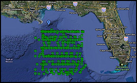
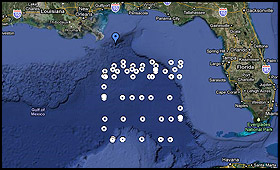
AXBT data and plots are available from two NOAA aircraft. The location of AXBT deployments (circles) for each mission are shown on the map below. For more information about the collection of these data see the inventory files below.
NOAA42 collected 15 profiles of salinity and 297 profiles of temperature (312 total) using 272 AXBT's and 25 AXCTD's from May 8 - July 24, 2010:
Plots, CSV, NetCDF, GTSPP ASCII, Inventory, Google Earth .kmz
NOAA49 collected 63 profiles of temperature using 63 AXBT's from May 18 - May 21, 2010:
Plots, CSV, NetCDF, GTSPP ASCII, Inventory, Google Earth .kmz
What is an AXBT? It's a water temperature probe, dropped from an aircraft, that measures the water temperature as it falls. The probe is designed to fall at a known rate, so that the depth of the probe can be inferred from the time lapsed from launch.
What is a AXCTD? An ocean instrument, dropped from an aircraft, that has a combination of a pressure sensor (measured pressure is converted to depth), a resistance temperature measurement device (usually a platinum thermometer), and a conductivity sensor used to estimate salinity.
Other Platform Data
The Development Driller III (DD3) semisubmersible drilling rig was deployed to the site of the Deepwater Horizon Oil Spill incident to assist in the drilling of a relief well. While on station, the DD3 utilized an Acoustic Doppler Current Profiler (ADCP) that used sonar to measure and record water current velocities, distribution of suspended material over a range of depths, and help predict Loop Eddy current interactions and forces on the platform. This record is a summary of ADCP data that the Development Driller 3 collected from May 31, 2010 - July 04, 2010. The data from this ADCP is raw and unprocessed, available data types include: Current Speed - East/west Component (u), Current Speed - North/south Component (v).
Available Data: ADCP
The Discoverer Enterprise (DE) ultra-deepwater drillship was deployed to the site of the Deepwater Horizon Oil Spill incident to assist in the collection of spilled oil. While on station, the DE utilized an Acoustic Doppler Current Profiler (ADCP) that used sonar to measure and record water current velocities, distribution of suspended material over a range of depths, and help predict Loop Eddy current interactions and forces on the platform. This record is a summary of ADCP data that the Discoverer Enterprise collected from May 23, 2010 - July 04, 2010. The data from this ADCP is raw and unprocessed, available data types include: Current Speed - East/west Component (u), Current Speed - North/south Component (v).
Available Data: ADCP
Unidentified-Platforms Data
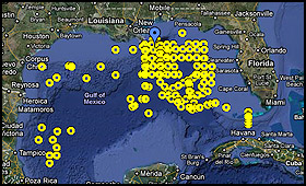
Included in these files are data from several vessels, including one aircraft survey. Several surveys were conducted and posted to the GTS as unidentified vessels, so all the call signs were set to "SHIP".
SHIP collected 91 profiles of salinity and 185 profiles of temperature (276 total) using 61 XBT's and 124 CTD's from April 22 - July 24, 2010:
Plots, CSV, NetCDF, GTSPP ASCII, Inventory, Google Earth .kmz
 Offsite Link Notification