FINAL REPORT
COMPLETED NOVEMBER 1996
PUBLISHED NOVEMBER 1997
U.S. FISH AND WILDLIFE SERVICE
Southern New England - New York Bight
Coastal Ecosystems Program
SIGNIFICANT
HABITATS AND HABITAT COMPLEXES
OF THE
NEW YORK BIGHT REGION
INTRODUCTION
The objective of this study was to identify regionally significant habitats and species populations in the New York Bight watershed and New York - New Jersey Harbor that would provide local, state, and federal resources agencies, planning agencies, conservation organizations, and the public with information essential to making informed land use decisions. Such decisions fully consider and value living resources and their environment to preserve regional biodiversity and restore and maintain the health of the New York Bight ecosystem for the continuing benefit of the American people. The Habitat Work Group of the New York - New Jersey Harbor Estuary Program, administered by the U.S. Environmental Protection Agency (EPA), initially identified this task in 1992 and requested that the U.S. Fish and Wildlife Service (Service) conduct a study and produce a report that identifies significant coastal habitats warranting special protection, summarizes their conservation status, and presents recommendations for their preservation and restoration. This report represents the final product of that effort. Partial funding for this project was provided by EPA, with the bulk of the funding coming from the Fish and Wildlife Service.
The New York Bight region is a vast and interconnected system of open ocean waters, fringing coastlands, and estuaries, plus an extensive upland watershed extending from the highest elevations and peaks of the Adirondacks, Catskills, Taconics, and New York - New Jersey Highlands, to the broad Hudson River valley, Newark Lowlands, and Coastal Plain flatlands of southern Long Island and eastern New Jersey. It also includes the predominantly open water region of the Atlantic Ocean lying offshore of southern Long Island and southeastern New Jersey and out to the edge of the continental shelf, approximately 160 kilometers (100 miles) seaward. It is this bend in the Atlantic Ocean coastline of the northeastern United States and the large body of ocean water enclosed within it that is referred to as the New York Bight and which gives both the region and this study area its name. The New York Bight is itself part of the still larger Mid-Atlantic Bight Region of the North Atlantic Ocean.
The New York Bight habitat study differs in several substantial ways from previous, more traditional approaches to identifying and protecting essential fish, wildlife, and plant habitats in this and other regions. In particular, its primary focus was identifying and delineating regionally significant populations and habitats of a select group of federal trust species (U.S. endangered and threatened species, candidates for listing under the Endangered Species Act, migratory birds, anadromous fish, and marine mammals), state-listed species, and regionally rare species occurring naturally within this extensive coastal region. The report emphasizes the recognition and delineation of large habitat complexes linking similar or related habitat types and local species populations into larger ecological assemblages on a landscape basis. Because small and isolated populations, particularly those of rare species, are highly vulnerable to local extinction and their habitats subject to rapid and adverse changes from human disturbances and modifications, the report promotes the protection and maintenance in their entirety of these larger, ecologically integrated habitat complexes that often contain a few to many smaller local populations and habitat units.
The value and purpose of identifying essential habitat linkages and incorporating smaller habitat units into larger habitat complexes is, in part, to design landscape areas that facilitate migration, recruitment, and recolonization by species from and among adjacent habitat areas. These areas become critically important in the event that individual local populations are extirpated as a result of internal and external factors; they also promote the recovery of endangered species. By emphasizing fairly large habitat complexes composed of several to many closely related habitat sites and/or interactive local species populations (metapopulations), there is the additional advantage for individual units within these complexes to be managed under more uniform and effective management practices than the site-by-site and relatively uncoordinated practices currently employed in most areas. Furthermore, there is an increased opportunity to engage all the individual landowners and managers within each of these larger habitat complexes into a cooperative conservation program without necessitating prohibitively expensive land purchases or operational costs.
Areas that were the subject of particular focus in this study include site-specific locations of naturally occurring populations of federally and state-listed endangered and threatened species and candidates for listing, and those areas that contain significant concentrations of, or are otherwise important to critical life-history stages of, other indigenous species. These are sites that are used regularly by such species, either seasonally or year-round, and not just sites of rare or accidental occurrences of a species. This report focused on, but was not necessarily limited to, the following use categories:
Other categories of special focus areas include those sites important to the maintenance of regional biological diversity, particularly areas containing several rare or regionally restricted species or natural communities; large tracts of forests or grasslands containing important concentrations or large numbers of nesting pairs of Neotropical migrants, especially declining species; and outstanding regional representatives of biological communities. While the emphasis of this study was on site occurrences and habitat use areas of extant populations, historical data was also sought and evaluated to identify potential restoration and recovery sites or areas such as critical "stepping stone" sites between extant and highly-localized populations or highly fragmented and disjunct populations such as occur within the urban core.
Geographic Boundaries and Area
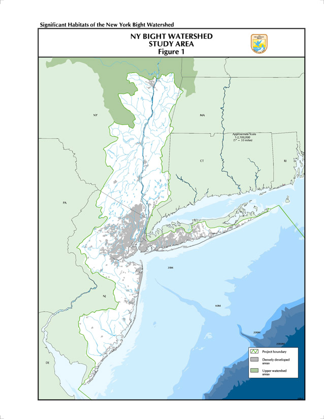
The boundary of the New York Bight study area encloses three distinct but intimately interconnected components: the open ocean region south of Long Island and east of New Jersey, known as the New York Bight proper; the New York - New Jersey Harbor Estuary and its associated bays, as well as the tidal waters of the lower Hudson River from the southern tip of Manhattan Island up to Troy Dam; and the land watersheds discharging their waters into the New York Bight, including that portion of the watershed of the tidal Hudson River below Troy Dam and the watersheds of southern Long Island and eastern New Jersey (Figure 1). The New York Bight proper consists of those ocean, coastal, and estuarine waters of the Atlantic Ocean lying south of Long Island, New York, from New York City east to Montauk Point, and east of southern New Jersey from Sandy Hook south to Cape May, extending seaward nearly 160 kilometers (100 miles) out to the limit of the continental shelf. The southern marine boundary of the Bight is defined by a line extending approximately southeastward from the mouth of Delaware Bay, at the boundary of the states of Delaware and New Jersey, out to the edge of the continental shelf in the vicinity of Baltimore Canyon. The eastern marine boundary of the Bight is defined by a line extending from the border of Rhode Island and New York, approximately midway between Montauk Point and Block Island, southeastward out to the edge of the continental shelf east of Block Island Canyon. In addition to the open Bight waters, the geographic scope of the New York Bight habitat study also includes the entire estuarine watershed and associated network of rivers, tributaries, and coastal streams either flowing directly into the Bight and the New York - New Jersey Harbor or into the tidal Hudson River system. The watershed area above Troy Dam, including all of the Mohawk River and its watershed and the upper reaches and watershed of the Hudson River and its origins in the Adirondack Mountains, is not included in the current study and report but is slated for a future report. The study area totals approximately 8.1 million hectares (20 million acres or 31,276 square miles), of which 2.6 million hectares (6.5 million acres or 10,206 square miles) are upland watershed and 5.5 million hectares (13.5 million acres or 21,070 square miles) are marine/estuarine waters.
Regionwide Threats and Conservation Considerations
As one of the most populous and heavily industrialized coastal areas in the world, the New York Bight region is subject to extreme social and economic use impairments and ecological impacts from urban and suburban development, industrial effluents, chemical and oil spills, human sewage, nonpoint source pollution, recreational overcrowding, floatable materials, atmospheric fallout of pollutants, dredging and dredged material deposition, over harvesting of fishery resources, competition from exotic and invasive species, and destruction of essential natural habitats. Yet in spite of more than 300 years of human settlement and consequent impacts on the native fauna and flora of this region, the Bight and its adjacent shorelands and uplands within the watershed are rich in living resources, although most are considerably diminished from their former levels of abundance in the region and their habitats reduced in extent or markedly changed from pre-colonial conditions. Moreover, most continue to be at substantial risk. In addition to their serving as essential components of functional, viable ecosystems, many of these living resources are of significant economic and social value to the 20 million people who live in the region, whether as edible or consumable finfish, shellfish, furbearers, waterfowl resources, upland and big game species, or as non-consumable watchable wildlife and plants such as backyard birds and woodland flowers.
The values to society of healthy fish, wildlife, and plant populations and their habitats are inestimable and diverse, as is their importance towards maintaining the ecological viability and health of coastal and marine ecosystems globally. This report recognizes and focuses on the urgent need to identify, evaluate, describe, and delineate crucial habitats of key coastal and marine species in the New York Bight region to help guide, in an ecologically sound manner, present and future land-planning activities, including both land development and land protection, in this important coastal region of the country. The report also emphasizes and addresses the need to develop and implement specific conservation recommendations and measures to protect, conserve, and/or restore these essential habitats to the greatest extent possible. The goal of habitat conservation is to maintain over the long term healthy, viable, and sustainable populations representative of the full regional diversity of species that depend upon these habitats, and which are, in turn, of such extraordinary and essential value to human populations dependent upon them for food, income, recreation, aesthetics, intellectual and spiritual enlightenment, and maintaining the global ecosystem.
A variety of approaches and strategies exists for the protection of valuable wildlife habitats; each provides different degrees of protection and requires different levels of commitment by federal and state resource agencies, municipalities, private conservation organizations, and landowners. These techniques range from establishing site-specific conservation easements and cooperative management agreements, developing zoning and land use regulations and comprehensive planning, aggressively enforcing existing local, state, and federal regulations, and negotiating tax incentives, mutual covenants, and land exchanges, to fee simple acquisition and designating national or state parks, forests, or wildlife refuges. Successful application of these protection mechanisms can be enhanced through their use together and in partnership with all parties involved. Selection of the most appropriate and effective combination of protection techniques and strategies should be determined only through careful consideration of the unique conditions and circumstances that apply to each individual site or complex. Specific conservation considerations are provided for each of the habitat complexes identified in this report.
Section 10 of the Rivers and Harbors Act of 1899 and Section 404 of the Clean Water Act of 1977 mandate a strong federal and, in the specific case of New Jersey, state role for protecting the nation's wetlands; these have proved to be very effective regulatory mechanisms for protecting wetland habitats in general. Both states in the study region have enacted special laws to protect coastal wetlands, and these laws vary considerably in their degree of protection. Federal and state permits are required for most types of construction in estuarine and inland wetlands. While the regulatory tools to protect wetlands are in place, continued vigilance and enforcement of existing laws are necessary to maintain the integrity of the wetlands that remain for their uses and values to people and to wildlife. The Fish and Wildlife Service and National Marine Fisheries Service are mandated by the Endangered Species Act, Anadromous Fish Conservation Act, and Migratory Bird Treaty Act to provide protection and restoration/recovery opportunities to species listed under them, including species that are not directly tied to wetland habitats. In addition to regulation, the Coastal Barrier Resources Act of 1982 removes federal subsidies and discourages development of designated coastal barriers and adjacent wetlands. Executive Order 11990, "Protection of Wetlands," requires federal agencies to develop guidelines to minimize destruction and degradation of wetlands and to preserve and enhance wetland values. There are also a number of state laws and regulations protecting endangered species and habitats; these are discussed in the section on state-listed species.
It is also hoped that this report and its specific conservation recommendations will be used to emphasize these regionally important sites in other plans and documents that focus on the New York Bight region, e.g., the Comprehensive Conservation Management Plan (CCMP) of the New York - New Jersey Harbor National Estuary Program and that being developed for the Barnegat Bay National Estuary Program, and various regional oil spill response and contingency plans being prepared by the U.S. Coast Guard.
Watershed or Ecosystem Approach
The Fish and Wildlife Service recently adopted an ecosystem approach to fish and wildlife conservation as an underlying foundation of its operational activities. This has included regional reorganization along geographic or ecosystem divisions, rather than along state boundaries or program area lines. It is the Service's view that a broad, holistic management strategy is an effective way to address the agency's mission to conserve, protect, and enhance fish and wildlife and their habitats for the continuing benefit of the American people, and to manage its extensive array of trust responsibilities such as migratory birds, anadromous fish, marine mammals, endangered species, wetlands, and the National Wildlife Refuge System. The goal of the Service's ecosystem approach is to effectively conserve biological diversity through perpetuation of dynamic, healthy ecosystems by means of coordinated efforts with public agencies, private organizations, landowners, and citizens. Most obvious are those actions that lead to the acquisition and/or protection of habitat, and the recovery of fish and wildlife populations in jeopardy. Less obvious, but equally significant, are actions that restore important habitats, reduce environmental degradation and contamination, monitor the health of natural ecosystems, regulate the harvest of migratory birds and fish, and provide technical assistance to private landowners. In its ecosystem approach, the Service focuses on three major areas of emphasis: to identify and meet fish and wildlife needs in the context of the entire environmental and socioeconomic landscape in which they occur; to increase cross-program collaboration within the agency; and to communicate, coordinate, and collaborate more frequently, more consistently, and more effectively with our partners, affected stakeholders, and the public.
The Fish and Wildlife Service has adopted the watershed as the basic ecosystem unit in implementing its ecosystem approach, identifying 52 large regional watersheds selected from the U.S. Geological Survey's (USGS) Hydrologic Unit Map as the framework for organizing and involving Service staff nationwide in its ecosystem approach. One of these ecosystem units is the Hudson River/New York Bight ecosystem, a watershed region that includes the New York Bight study area and the upper Hudson River watershed.
The watershed may be defined by the ridgeline or elevation contour that delimits a drainage basin, i.e., all the area drained by a river or a system of rivers and tributaries. The watershed may logically serve as the natural ecosystem boundary for ecosystem approaches to natural resource management because changes at one point in a drainage basin may have ramifications in other parts of the basin that are spatially and/or temporally removed from the point of original change, and because water flows downstream from the watershed through the drainage basin, thereby integrating influences of natural and human disturbances within the basin. While aquatic and terrestrial systems within a drainage basin have their own distinct structural and functional properties, the two components are too interrelated and linked on a geographic scale to consider them separately. Furthermore, in a river drainage basin, land and water are a hydrological continuum.
The focus area of this study, the New York Bight region or Hudson River/New York Bight ecosystem, may be viewed as a coastal or estuarine drainage area or watershed. This may be defined as a specific coastal area or estuary consisting of the entire interconnected and integrated ecosystem complex of estuarine, coastal, and nearshore marine and estuarine environments, together with all associated inland rivers and streams from their headwater origins at the drainage divide to their mouths, plus their land-based drainage basins.
Watershed ecosystems consist of many distinct habitat units, or patches, that vary in time and space over the extent of the drainage basin and associated coastal areas with changes in land elevation, water velocity, substrate type, disturbance, and so on. River and coastal basins may thus be characterized as patch-dynamic systems. In any given reach of river, section of coast, or estuary, the distribution, abundance, and interrelationship of organisms and biotic communities are related to the distribution of these habitat patches. Habitat patches are, in turn, a function of the structural and functional features of the basin landscape, e.g., river channel, shoreline, floodplain, groundwater, mudflats, dunes, and sandbars, as they interact within time and space with the geomorphology and hydrology of the drainage basin. In a patch-dynamic system, the ecological connectivity of patches is a fundamental feature. Maintaining the linkages among patches of habitat is vital to the management of river and coastal ecosystems.
Disturbance events alter the structural and functional connectivity of river and coastal ecosystems. Disturbances, catastrophes, and interannual variation in drainage basins are natural and regularly-occurring events in such ecosystems. It is human disturbances that are often more extreme in frequency, intensity, and duration than are natural events and that serve to uncouple important ecological processes linking ecosystem components in large river basins. In many drainage basins, human disturbance has eliminated or severely compromised natural connectivity. The principal goal, therefore, of managing a river drainage basin and/or coastal drainage basin ecosystem is to sustain the natural ecological connectivity and linkages of the system in order to ensure the survival of its indigenous biotic communities and maintain its biological diversity.
Watershed or ecosystem approaches to resource management must involve maintaining or reconnecting patches into landscapes. In keeping with the Fish and Wildlife Service's ecosystem approach to fish and wildlife conservation and the basic principles and concepts described above, the New York Bight habitat study focused on those regionally significant species and habitats occurring entirely or predominantly within the New York Bight and its watershed. Furthermore, in recognizing the need to maintain the linkages and ecological connections within a regional watershed and ecological landscape, the emphasis of this study has been on the identification and delineation of large regional habitat complexes of interrelated habitats within the New York Bight watershed.
This study and report were initiated for the purposes of assessing the status of selected regionally significant native fish, wildlife, and plant populations and their essential habitats in the New York Bight region, especially those requiring both immediate and long-term protection, conservation, enhancement, and/or restoration. The study also looked at the types and degrees of perturbations and threats to the physical integrity of these habitats and threats to species populations dependent upon them, and determined, delineated, and described those specific habitat areas and habitat complexes felt to be of regional importance or significance. As used in this report and in the previous Northeast Coastal Areas Study(1), "significance" of a site or resource refers to its relative regional importance to one or more life history stages or seasonal-use periods of federal and state trust species and other species of special emphasis or concern, listed in Appendix I. It is not meant to infer any statistical level of significance or quantitative ranking system. For example, the presence of a population, regardless of size, of a federally listed or state-listed endangered or threatened species, the exemplary occurrence of a regionally scarce community type, a large wintering concentration of waterfowl in numbers or densities considerably greater that what is generally encountered in the region, areas with a high diversity of trust species, and a highly vulnerable breeding or spawning area of a fish or bird species that has been substantially reduced or had its habitat qualitatively degraded from historical times, may all be considered "regionally significant" sites or resources in the context of this report.
Species of Special Emphasis
As a first step toward identifying regionally significant habitats, the New York Bight habitat study focused on the regional geographic distribution, individual site occurrences, and population status of a large number of selected key species -- species of special emphasis (Appendix I) -- occurring in the New York Bight region study area. In particular, these included those species of national or regional significance for which there is a clear federal or state trust responsibility under one or more legal authorities or mandates, such as the U.S. Endangered Species Act, Fish and Wildlife Coordination Act, Migratory Bird Treaty Act, Marine Mammal Protection Act, Anadromous Fish Conservation Act, North American Waterfowl Management Plan, New York State Environmental Conservation Law, New Jersey Endangered and Nongame Species Conservation Act, and New Jersey Endangered Plant Species List Act. Many of the key species and their habitats recognized in this report are rare or declining throughout the region and, in several cases, are globally threatened with extinction. They are especially vulnerable to loss, fragmentation, or degradation of their essential habitat, to human disturbances or intrusions, to competition with or predation by exotic species or feral animals, and to disease, overexploitation, and environmental contaminants. Other species, while not especially rare or seriously declining at the present, are nonetheless of considerable ecological, commercial, or recreational importance in the Bight and warrant close monitoring to ensure their long-term viability; they also serve as indicators of overall ecosystem health. Similarly, many of the habitat types upon which these species depend are themselves rare, depleted, declining, or threatened throughout the general region and in need of focused protection and/or restoration efforts.
During the initial stages and throughout the study, the Fish and Wildlife Service worked closely with the resource agencies of the states of New Jersey and New York, principally the state fish and wildlife divisions and the Endangered Species, Non-game, and Natural Heritage programs, to develop lists of target species for each state and to compile a comprehensive working list of species of special emphasis specific to the New York Bight watershed as a whole. Using the best and most recent population status and geographic distribution information available, the Service coordinated with state and federal cooperators to individually rank the abundance/rarity and watershed status, as compared with state or global status, of each of these species in the New York Bight region in accordance with a ranking system specific to the New York Bight region developed by the project office and an interagency work group. These rankings allowed the Service to fine-tune the priorities set for those species of special emphasis upon which the study's habitat identification and delineation efforts were further focused and directed. While species occurrences and populations formed the foundation of this study, the principal goal at all times was to use the species information to identify and delineate those habitat areas of regional importance to biological diversity, especially those in need of protection, restoration, or enhancement, and to give those areas and associated species increased public recognition.
The list of species of special emphasis developed for the New York Bight study region consists of approximately 114 species of invertebrates (mostly insects), 232 species of birds, 31 species of reptiles and amphibians, 38 mammal species, 99 species of fish, nearly 500 species of plants, and 82 natural communities. These species comprise a number of special focus groups of federal and state trust species in the Bight, including:
The list of animal species of special emphasis, list of plant species of special emphasis, and definitions for all codes used in the list are provided in Appendix I. Species of special emphasis lists for each habitat complex are included with the habitat narrative.
Data Compilation and Analysis
Subsequent to the development and finalization of the species list for the Bight, the Service obtained and compiled all pertinent information on the distribution and specific site occurrences of the species of special emphasis for which data were readily available. Along with species distribution and site occurrence data, information was also compiled on the habitats they currently and formerly occupied, and the threats facing both the physical integrity and quality of these sites. Much of the species and habitat data upon which subsequent analyses and this report were based were drawn from the resource agencies of the two states, particularly the Natural Heritage and Endangered and Non-game Species programs. In addition, data were received from various other programs and agencies in the region; these include state and federal coastal offices, Fish and Wildlife Service field offices and refuges, Regional Office technical staff, research units of the National Biological Service, several federal agencies (National Marine Fisheries Service, Environmental Protection Agency, National Park Service, Army Corps of Engineers, and Forest Service), other state agencies, municipal agencies, universities, state museums, research institutions, state and local environmental organizations, especially The Nature Conservancy, knowledgeable individuals, and literature searches.
Geographic Information System (GIS)
For this project, the Service's Coastal Ecosystems Program office in Charlestown, Rhode Island used a UNIX-based Geographic Information System (GIS) employing ArcInfo software to track and aid in the compilation and analysis of the geographic occurrences and population status of selected species of special emphasis occurring natively in the New York Bight region. In addition, this office developed, refined, and/or obtained dozens of map data sets of landscape features, political and regulatory designations, and natural resources; these were used to more accurately and usefully portray the distributions of the species and species groups of special emphasis, and to assist in the identification and delineation of significant habitats and habitat complexes from a landscape or ecosystem perspective over the entire New York Bight coastal watershed study area. These map layers included watershed and sub-watershed basin maps and hydrology, coastal and offshore bathymetry, coastline, urban areas, physiographic regions, wetlands, bedrock and surficial geology, significant state habitats and priority sites for biodiversity, waterfowl concentrations, anadromous fish streams, dams, state-managed and federally managed areas (parks, refuges, forests), and ecological zones.
With the exception of rare species data compiled and maintained by the state Natural Heritage Programs, many of these data sets were not generally available from centralized or well-coordinated information repositories but, instead, were often held by the office or individual who had taken the time to develop them and who had a professional responsibility for managing and protecting the associated resources. Obtaining existing data sets for this project required many hours of discussion with the authors to understand the functional limits and technical format of the data and to explain our intended use of the information, since in many cases the data represent site-specific information on resources that are particularly sensitive to human disturbance or misinterpretation. Due to the large geographical and biological scope of this project, our requests often amounted to a significant portion of the information collected by an agency office; therefore, before obtaining copies of information for this project, we regularly needed to agree to restrictions on the distribution or presentation of the raw data. This was particularly true of map information in both digital and paper form. In several cases, formal cooperative agreements were established to recognize the concerns of the agencies sharing materials with us; these specified restrictions limiting our use of the data for planning and analysis purposes related to this project only. These agreements do not prevent us from publishing or sharing data that are synthesized from the original information.
Habitat Delineation
Using computer-generated GIS maps and overlays, site locations and occurrences of all species of special emphasis in the New York Bight region were graphically portrayed using GIS tools and analyzed at map scales most appropriate to show their patterns of occurrences and environmental preferences over the project region. These geographic analyses and maps helped to reveal the spatial relationship of specific species populations to other populations of the same, related, and/or different species over the region in order to determine: levels of local, watershed, and regional rarity or abundance; central population core areas; seasonal use concentration areas; areas of concentration of many species (high biodiversity indices); landscape (aquatic and terrestrial) dispersion patterns; commercial harvest areas; connectivity between populations and between similar or interrelated habitat types; migration and dispersal corridors; areas of potential, but currently unoccupied, habitat; metapopulation boundaries; habitat buffers; and many other factors that serve to identify significant species habitat areas in the region. Species distribution was correlated with significant landscape features such as landforms, hydrology, wetlands, geology, and open space to determine habitat boundaries. Refinement of site boundaries, linkages between habitats, assessment of extant local populations, field validation of data, and actual map delineation of significant habitat areas and complexes of individual sites were carried out over the course of many months through a series of intra-Service analyses and external consultations with cooperative agencies, especially the states, until reasonable final habitat boundaries were obtained. It should be noted and emphasized that these boundaries are biologically-based and, therefore, approximate and relatively broad. They should not be viewed or used as regulatory boundaries. They may be used, however, to develop more site-specific regulatory or zoning boundaries by local, state, or federal governments.
In identifying specific significant habitats in the Bight region in need of protection, the project followed protocols and procedures developed for the Northeast Coastal Areas Study, in that it focused on individual populations or occurrences of species of special emphasis; regionally or nationally significant habitat sites of special emphasis species and/or areas of exceptional biological diversity or community uniqueness; and habitat complexes consisting of two or more, and often several, important and ecologically-linked habitats within a given geographic area. A knowledge of the distinctions between each of these approaches is necessary to understand the rationale behind the identification and delineation of the sites presented in this report.
Individual occurrences of species of special emphasis were analyzed to identify areas important to one or more critical life history stages, such as spawning, nesting, wintering, or juvenile growth areas, of these species. Data were sought and collected from all available sources on individual site occurrences, both current and historical, of the over 1,000 selected species of special emphasis. These ranged from small and local resident breeding populations and seasonal clusterings to larger metapopulations, overwintering and migration concentrations, and anadromous fish runs. These data were analyzed for the entire Bight and Bight watershed study region. Distribution and locality information was collected and compiled at the most detailed scale and format available, generally on 1:24,000 standard USGS topographic quadrangle maps and occasionally on smaller scale maps. The bulk of this information was obtained from the two state Endangered Species and Natural Heritage Programs and other natural resource agencies and offices, federal agencies (Fish & Wildlife Service, National Marine Fisheries Service), and private conservation organizations (The Nature Conservancy, National Audubon Society). Individual occurrences and locations were pinpointed on base maps as precisely as the data would allow, either as point occurrences or larger area delineations, often to the nearest second of latitude and longitude; where appropriate, polygons showing use areas, e.g., waterbird nesting colonies, were also mapped. This information was then entered into the project office's GIS to facilitate storage, retrieval, analysis, and graphic presentation of data. Whenever possible or practical, all occurrences of a species in the study area were recorded, including historical locations, regardless of number of individuals at a site, population size, resident or breeding status, or regional or national significance. In some instances, however, particularly in the case of widespread species showing considerable movement over the general area such as waterfowl and marine fish, only the more stable and regularly-occurring concentrations were approximated and mapped.
Using the species occurrence data along with appropriate habitat and landscape data layers, important or potentially important habitat sites were identified. Prior to this project, many important individual habitat areas were already recognized, at least from a statewide perspective, for their value to fish, wildlife, and plants by various state resource agencies and conservation organizations and were recommended for inclusion in the final report as significant habitats in need of protection. Because this study focused its data compilation and analysis efforts primarily on habitats of regional or national significance, differences were to be expected between the two perspectives, although these were surprisingly few. In the case of New Jersey, many important habitat sites had been previously analyzed and delineated by the New Jersey Department of Environmental Protection's Endangered and Nongame Species Program and Natural Heritage Program. The Service worked closely with biologists from these two programs to understand how these sites, referred to as scorecard sites or priority sites for biodiversity, had been delineated and, in several instances, how the delineations could be improved or updated. The New York State Departments of Environmental Conservation and State had also identified and designated a number of important habitat types, called significant fish and wildlife habitats, both along the coast and along the tidal reaches of the Hudson River. The New York Chapters of The Nature Conservancy had identified several priority sites for biodiversity similar to those identified by the state of New Jersey. Subsequent and continued discussions with knowledgeable field biologists in both states and some field verification were undertaken to determine and/or confirm the regional importance of these sites. Candidate sites recommended by the states were further evaluated and analyzed as part of the present study to determine their overall regional or national significance to fish, wildlife, and plants in the Bight study area. In addition to obviously significant and exceptional sites, i.e., those supporting disproportionately large numbers or densities of a species or where breeding success and productivity are particularly high or above average, the data also served to identify important intermediate sites between major areas that function as migration or recruitment linkages between local populations.
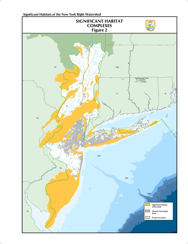
The Service also identified significant habitat complexes through analysis of species occurrence data and consultation with others (Figure 2). Analyses of species and habitat data highlighted significant landscape features of the watershed ecosystem, such as barrier beaches and coastal lagoons, unfragmented, continuous blocks of forest and wetland areas, pine barrens, and freshwater tidal marshes. These larger units generally consisted of from two to several individual habitat units that are each important to a single species, multiple species, or communities, and are either contiguous, continuous, adjacent, or in relatively close proximity to each other so as to allow their being recognized as a single, interrelated ecological unit, particularly from a natural resource management perspective. Each of the habitat units within these complexes was, in most instances, individually recognized as being important to either a single species or a group of species, often by an agency or group focused on a particular group of species or a site. What this study attempted to do is identify obvious linkages between significant sites, allowing them to be viewed and managed in a much larger and ecologically relevant context. The majority of significant habitat sites identified in this report are primarily habitat complexes composed of many individual, smaller habitat units, including many individual preserves, state-managed and federally managed lands, and priority sites for biodiversity. Probably more than any other factor, it is this complexing of habitats over regional and multi-state landscapes that distinguishes this project and its products from state and local level analyses.
Habitat complexes generally belong to one of three categories: contiguous or continuous similar habitats, e.g., linear stretches of beaches or dune systems running parallel to the coast, mountain ridgetops, unfragmented forest stands, or riparian corridors; contiguous or continuous dissimilar, though geomorphologically and often ecologically related, habitats, e.g., barrier beach/lagoon/salt marsh/upland complexes or local watershed complexes of wetlands and adjacent uplands; and discontinuous, though not necessarily remote, similar habitats that form an essential part, if not the entirety, of a species' population or metapopulation, e.g., offshore islands, high elevation mountain peaks, or river marshes along the Hudson.
Once the final habitat boundaries were determined, maps and map overlays were prepared with the aid of computerized GIS software and hardware. Although several scales, ranging from 1:24,000 to 1:500,000, were used during the course of the project, the final base map scale used in this report is 1:100,000, the same as the scale of USGS maps that are commercially available for the region. Small-scale regional maps were also used to show large regional patterns. An overview map at 1:500,000 precedes the narratives for habitat complexes within each physiographic region.
Site Narratives and Maps
A description of each habitat complex accompanies the site maps in this final report. The site descriptions contain essential information on each complex:
These site narratives were neither intended to be highly detailed and comprehensive discussions or descriptions of each area nor to provide a complete bibliography of all that is known or has been published to date for each site. Rather, they are summaries of the important ecological values, threats, and conservation considerations for each site intended to highlight areas of exceptional regional significance to fish, wildlife, and plant resources in the New York Bight and watershed. Their purpose is to provide these areas with increased protection or restoration, and to serve resource managers, land planners, citizens groups, regulatory agencies, and others in their land use decision-making.
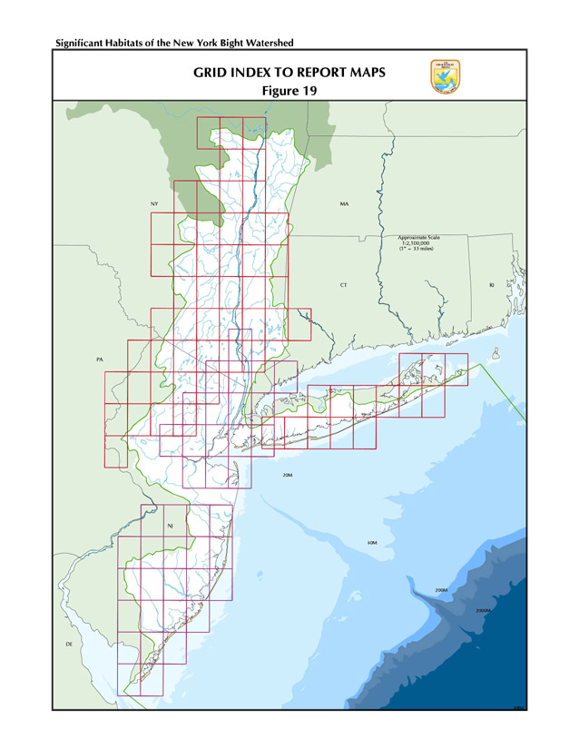
Site maps of each habitat complex were designed to be displayed using standard 1:100,000 scale USGS maps as background images. The page limits for maps in this section of the report were defined to minimize the number of maps needed to display a habitat complex, yet maximize the number of map pages that would edge-match to neighboring pages. This resulted in four page grids that cover the study area (Figure 19). The cells in each grid represent an area where one or more maps were created for the site narrative sections of the report.
1. The Northeast Coastal Areas Study identified, mapped, and described significant coastal habitat complexes in southern New England and Long Island.
Return to table of contents