3. Brief Summary Expeditions
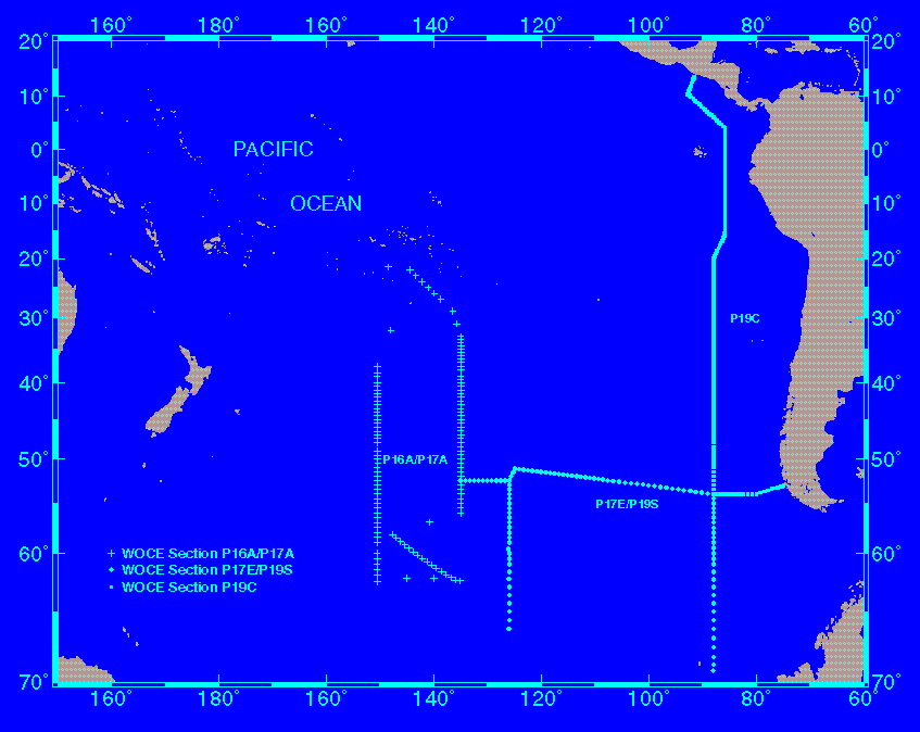
3.1 WOCE Section P16A/P17A
R/V Knorr departed Papeete, Tahiti, on October 6, 1992, to extend southward the WOCE Pacific Sections P16 and P17 completed by the R/V Thomas Washington TUNES-2 expedition during July-August, 1991. Two equipment checkout/training stations were done enroute to the first scheduled station at 37.5°S, 150.5°W, a reoccupation of TUNES-2 station no. 180. Both training stations were done by 36-place 10-L bottle rosette/CTD casts to the bottom with duplicate sampling of the standard hydrographic water samples. Station no. 2 was occupied at 32°S, near the WOCE P6 line completed in June 1992 as part of this R/V Knorr voyage in the South Pacific Ocean.
From station no. 3 the cruise track ran south taking stations at 30-nautical mile (30-nm) intervals (i.e., ~55-km) along 150.5°W (see Fig. 1), intending to reach the vicinity of WOCE line S4P at 67°S, which was completed by the Russian R/V Akademik Ioffe in March 1992. However, the ice pack was still near its maximum seasonal extent during the austral early spring. Large icebergs were first seen at about 58°S, and streamers of pancake sea ice 4 miles south of station no. 53 at 62.5°S forced the captain to turn around for safety reasons. The ship hove to during the short nights while it was in the vicinity of ice and icebergs for the next week. From station no. 53, the ship steamed eastward, taking two small volume stations on the deadhead run to the corner stations at 62.5°S, 135.0°W in the Amundsen Basin. The Gerard and rosette casts were unusually far apart on station no. 56 because the ship had to move to avoid a rampaging iceberg; the iceberg was 5 miles away at the start of the deep Gerard cast and had closed to within 2 miles by the end of the cast. From station no. 56, an arc of station positions was laid out roughly normal to the trend of the Pacific Antarctic Ridge. Station no. 71 was at the crest of the ridge. The rationale for this line of stations was two-fold: to examine any possible Ross Sea bottom-water flow along the flanks of the rise upstream of the Udintsev and Eltanin Fracture Zone systems and to have a line of stations underneath the 10-day repeat satellite track to compare geostrophic sea-surface elevation and satellite altimetry. Earlier satellite-tracked drifter tracks and sea-level elevations from satellite altimetry have indicated the presence of recurrent eddies near the ridge. From station no. 71, a single station was done to the bottom of the Udintsev Fracture Zone on the long deadhead run starting the WOCE P17 Section at 56°S and running northward along 135°W. Station spacing of 30-nm intervals was resumed until the TUNES-2 repeat station no. 179 was reached at 33°S. During the northward run, the ship discovered that it had a 50% greater speed capability than it had on the southward run; as a result the planned WOCE work was completed 3 days ahead of schedule. The extra available ship time was used to flesh out the historical deep station array by taking a few deep stations in the data-sparse regions in the deep trough between the Austral Islands and the Tuamotu Archipelago, avoiding areas covered by P6, SCORPIO, TUNES, GEOSECS, and PHOENIX expeditions. Having completed 127 stations, the number originally planned prior to the cruise, the ship arrived ahead of schedule in Papeete on the afternoon of November 25, 1992 local time.
All 127 CTD/rosette stations were occupied close to the bottom. Large-volume casts were done at 14 stations; most were single deep casts because extraction reagents were limited by a misplaced replacement shipment.