Results
Nearly 200,000 surface seawater and 50,000 marine air xCO2 measurements were made with the Princeton underway system during the 14 months of the Indian Ocean survey. With the exception of leg I8S/I9S, all of the components of the system worked very well and the data are believed to be of the highest quality. This section briefly discusses the overall trends observed in the data and any major events relevant to the final values. All of the events described have been carefully examined and appropriate action has been taken to maintain the quality of the data presented in this report. All times are reported in day of the year relative to 1995 with time of day represented as a fractional day (i.e., noon on 1/1/95 = 1.5) to correspond directly with the time stamp recorded with the data.
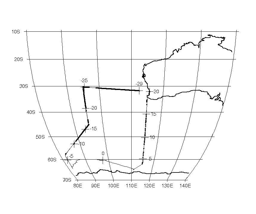
As mentioned previously, leg I8S/I9S was the most troublesome of the entire Indian Ocean survey. The R/V Knorr departed Fremantle, Australia, on December 1, 1994 (1995 day -29) with the system functioning normally. Aside from short system shutdowns due to overloading circuit breakers, the system worked relatively well until day -20 when the ship encountered strong winds and heavy seas. The ship's bow pump system did not function properly when sea conditions resulted in the uptake of a large number of bubbles or when the inlet came completely out of the water. The bow pump was off and on for the next several days. On day -11.33 the seawater supply for the equilibrator was switched to a secondary pumping system that was thought to be more reliable in rough weather. The secondary system, however, significantly heated the water before it reached the equilibrator. The degree of heating was extremely variable and was, at times, as much as 25°C. Although the degree of heating was documented in the difference between the calibrated sea surface temperature and the equilibrator temperature, attempts to correct the xCO2 values to in situ conditions yielded unrealistic results. The data from the first 10 to 20 days of the cruise should be reliable. However, most of the data collected after switching to the secondary pump were deemed unreliable (see Fig. 6A and Fig. 6B). Although some data from the last 20 days of the cruise appeared to be reasonable, care should be taken in placing too much confidence in these results.
After the ship returned to Australia, the system was cleaned up and examined by C. Sabine of PU. Upon examination it was discovered that the CO2 signal from the detector was unusually noisy (±0.01V). The noise problem was resolved by adjusting the setting on the rack temperature controller from 35 to 33°C. It was later discovered that this model LiCor detector had a substandard timing light emitting diode (LED) that was apparently in the process of failing. Lowering the temperature temporarily fixed the problem until the LED degraded enough to become a problem at the lower temperature (several months later). A replacement detector provided by LiCor was installed at the end of leg I8N/I5E and operated for the rest of the survey.
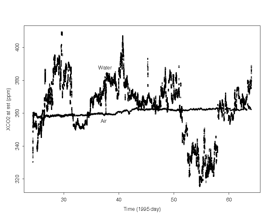
For leg I9N, lowering the rack temperature to 33°C seemed to fix the problem. The ship departed Fremantle, Australia, on day 24.3333. The water CO2 concentrations were generally higher than the atmospheric concentrations for most of the cruise, with the exception of the Bay of Bengal where some of the lowest CO2 concentrations of the survey were observed (Fig. 7A and Fig. 7B). The weather was generally calm, so very few problems were experienced with the bow pump. The reference gas was changed to tank ALM008242 on day 40.3993. On day 59 a new data collection program was installed that read and recorded the IMET and NAV data from the ship's computer whenever a CO2 data point was collected. Up to this time, the relevant IMET data were extracted after the cruise from the ship's one-minute files. The system was shut down on day 64.125 as the ship made its final approach to Sri Lanka.
Leg I8N/I5E departed Sri Lanka on day 69.5366 and headed south. The CO2 concentrations of the waters south of Sri Lanka were generally 10 to 20 ppm higher than the atmospheric concentrations, but dropped quickly to values very near atmospheric at around 10° S (Fig. 8A and Fig. 8B). The system generally ran well throughout the cruise, although post-cruise analysis of the data indicates that the time spent trying to analyze the standards started getting significantly longer around day 82. The reason for this lengthening is not known since this phenomenon was not noticed while the system was running. It is possible that the system got noisy again most likely because of the continued degradation of the timing LED in the detector. The problem did not seem to affect the data quality, only the length of time it took for the detector to stabilize and thus the quantity of data collected. When the ship returned to port in Fremantle, Australia, the LiCor was replaced with a new model from the factory.
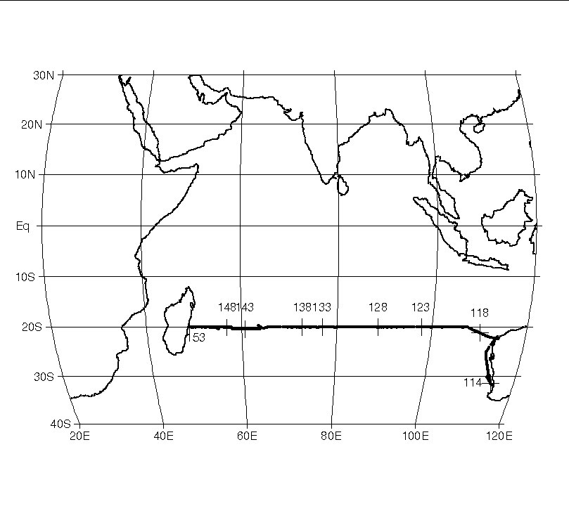
Leg I3 was the first zonal leg of the survey. The R/V Knorr left Fremantle, Australia, on day 113.0040 and headed north along the Australian coast to approximately 20° S. The surface water CO2 concentrations near the Australian coast were variable, but after the ship turned west there was a general decrease in CO2 concentration until approximately 135° E, then a slow increase as the ship approached Madagascar (Fig. 9A and Fig. 9B). The data gap between days 145 and 148 was the result of a short port stop in Mauritius. Aside from the detector being changed before the start of this leg, the only significant change to the system was a small modification to the chemicals in the drying column. Prior to this cruise, the chemical drying column was filled with magnesium perchlorate. Because it was difficult to determine when the perchlorate was becoming saturated, all cruises after this point used a column made up half with magnesium perchlorate and half with aquasorb (which changes from purple to black as it absorbs water). The reference tank was changed on day 144.2062, approximately 12 days before the end of the leg.
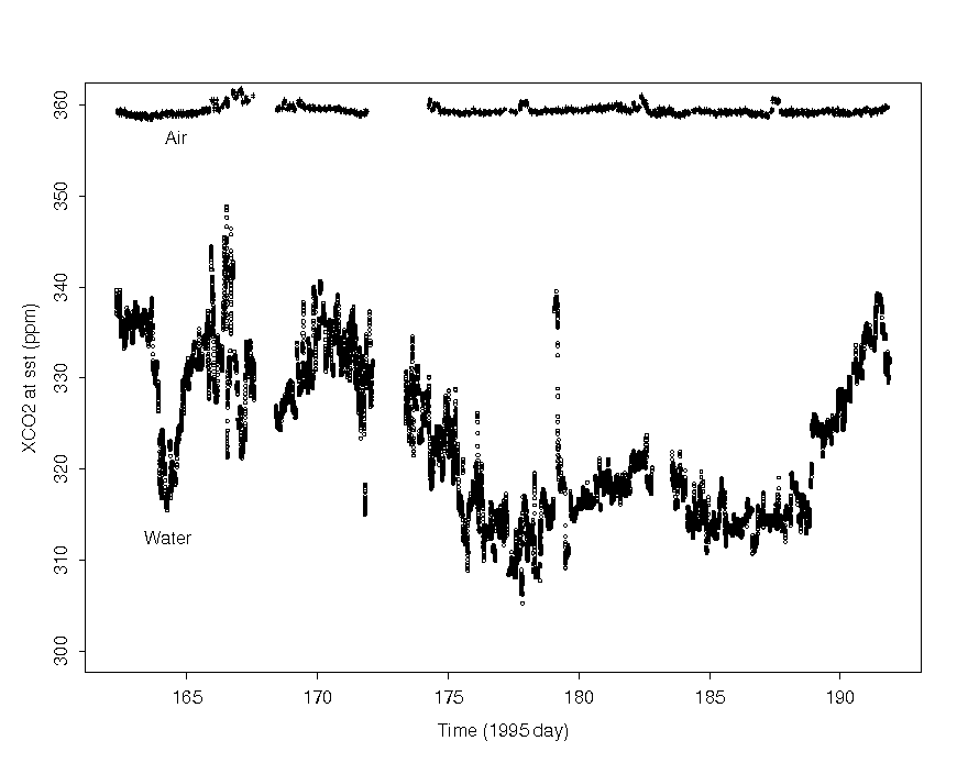
Leg I5W/I4 departed Mauritius on day 162.19 and returned on day 192 after a short port call in Durban, South Africa, around day 172. The surface water CO2 concentrations were significantly lower than atmospheric concentrations for the entire leg (Fig. 10A and Fig. 10B). The only significant problems with the system were encountered around day 168 because of a temporary mechanical problem with the equilibrator and on day 183 because of an extended bow pump shutdown caused by severe weather.
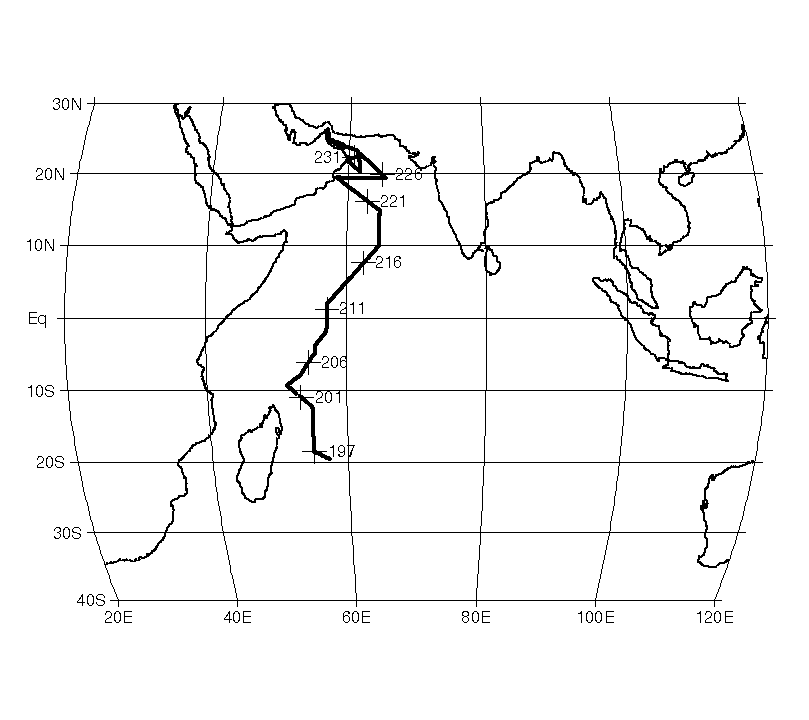
The R/V Knorr departed Mauritius on 196.3125 and headed north on leg I7N. Surface seawater CO2 concentrations increased from approximately 20 ppm below atmospheric concentrations to approximately 20 ppm above atmospheric concentrations near 10° S (Fig. 11A and Fig. 11B). The highest CO2 concentrations (>600 ppm) were observed off the coast of Oman because of upwelling caused by the southwest monsoon. The monsoon also made the seas very rough, resulting in frequent bow pump failures. The failures were generally short and care was taken to flag the bad data. The reference tank was changed twice during this cruise. The first tank was replaced on day 206.4868 with a zero-CO2 reference (tank 24813) since the 200 ppm references tanks were all exhausted. Tank 24813 had apparently leaked in shipping since it started with a pressure of only 700 psi. The reference tank was changed again on day 227.3958 to tank 18260.
Leg I1 departed Oman on day 241.4167. Before the system was started, the equilibrator was thoroughly cleaned. Unfortunately, during the cleaning the equilibrator PRT was broken. It was replaced with a spare that was calibrated to the initial PRT in post-cruise data processing. The high surface water CO2 values observed at the end of leg I7N were also observed at the beginning of leg I1 (Fig. 12A and Fig. 12B). The surface values generally decreased as the ship sailed away from the primary upwelling region. The ship took a short break in Sri Lanka from day 271 to day 273 before continuing on to the Straits of Malacca. The system was shut down as the ship entered Indonesian waters on day 286.4.
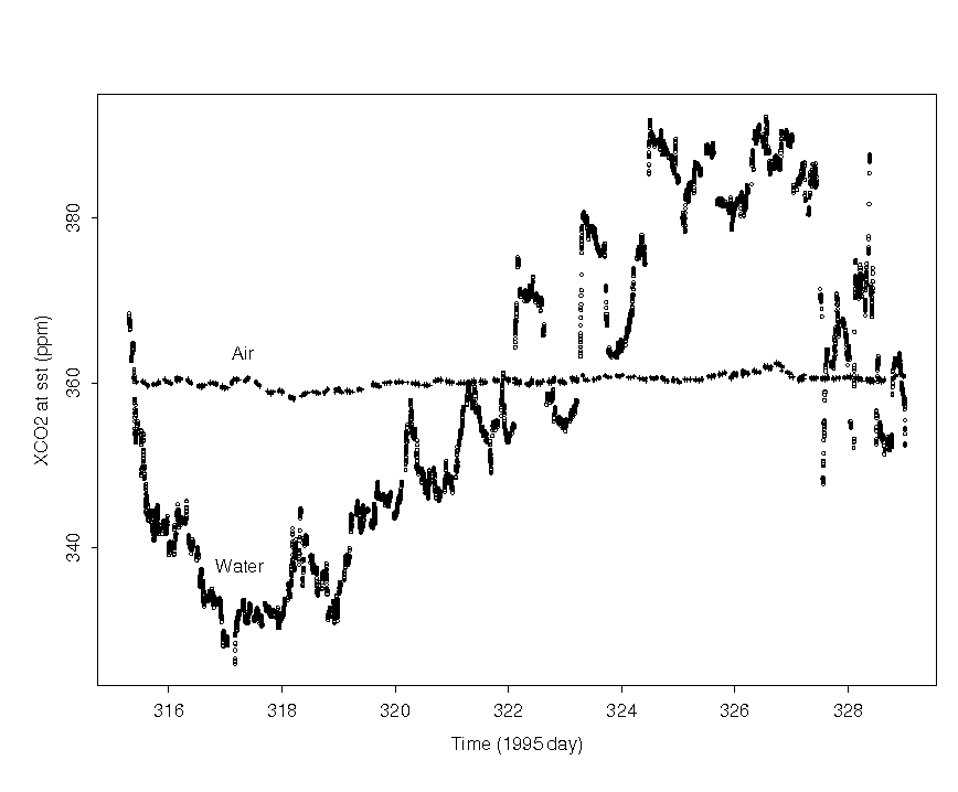
All systems were shut down for the 3 weeks that the R/V Knorr spent undergoing repairs in Singapore. C. Sabine and G. McDonald boarded the ship on day 303 and thoroughly cleaned and rebuilt the system during the transit from Singapore to Australia. New calibrated reference gases arrived at the ship, so tank ALM061365 was installed as the new reference gas. The LiCor detector also appeared to have had a slow drift in the zero voltage setting over its months of operation. The reference voltage had slowly drifted from 0.1 V when the detector was first set up on leg I3 to nearly 0.6 V by the end of leg I1. This voltage was reset to 0.1 before leg I10 using the zero adjust control on the LiCor. The ship's electronic technician was changing the IMET system around during the transit, so the underway system software had to be modified accordingly. The ship departed Dampier, Australia, for leg I10 on day 315.2943. The surface water CO2 concentration decreased as the ship traveled south, then increased again as the ship turned north (Fig. 13A and Fig. 13B). The highest xCO2 values were observed in the Indonesian throughflow waters at the northern end of the section. The system was shut down on day 329.0104 as the ship crossed into Indonesian territorial waters. The only problem noted on the cruise was a loose connector on the atmospheric pressure sensor on day 322. The loose connector resulted in very noisy pressure readings that, in turn, resulted in noisy pressure normalized voltages. The bad pressures during the affected time period (days 322.5 to 323.5) were replaced with the ship's atmospheric pressure readings calibrated to match the underway system pressures preceding and following the affected times.
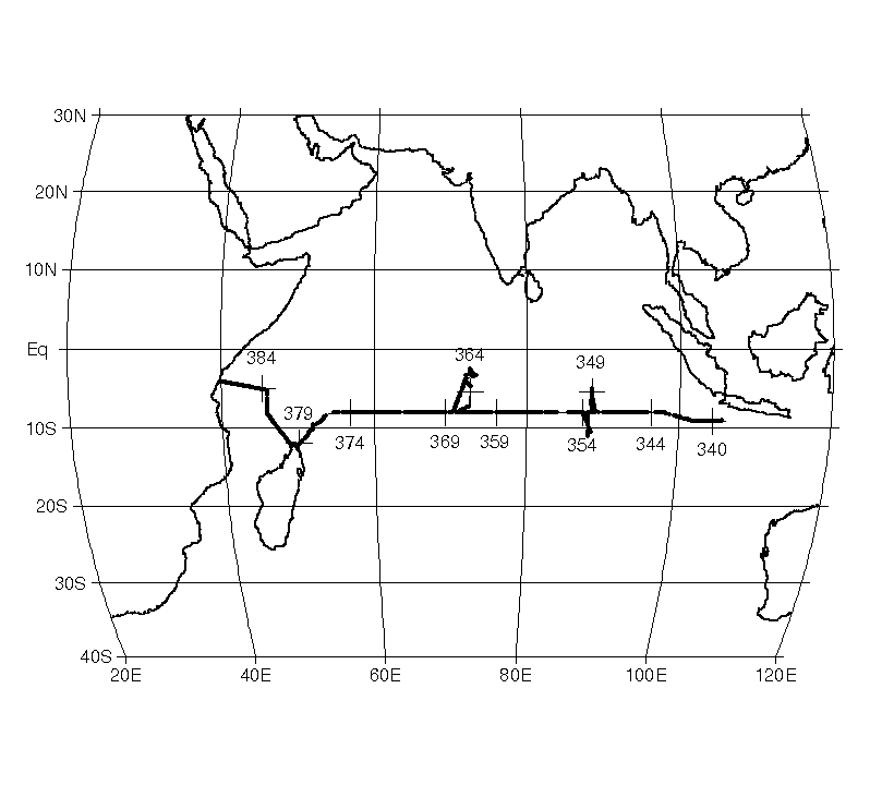
The final leg of the survey, I2, started on day 339.2764 as the ship cleared the Indonesian territorial waters. The surface water CO2 concentration generally increased from east to west (Fig. 14A and Fig. 14B). The large data gap seen in Figs. 14A and 14B from day 361.5 to day 364.3 is the result of a port stop in Diego Garcia. The smaller gaps resulted from frequent system crashes caused by the inconsistent transmission of the IMET data by the ship's computers. The Indian Ocean survey ended in Mombasa, Kenya, on day 386.6076 after covering a total distance of ~92,000 km.