EXECUTIVE SUMMARY
This assessment, prepared by the U.S. Fish and Wildlife Service's Southern New England - New York Bight Coastal Ecosystems Program, focuses on the identification and description of essential habitats of key marine, coastal, and terrestrial species inhabiting the New York Bight watershed study area in order to help guide informed and ecologically sound land use decisions and land protection efforts. The report also emphasizes the need to implement specific conservation recommendations and measures to protect, conserve, and/or restore these habitats and their dependent species populations. Particular emphasis is placed on the identification of large, interrelated or interdependent habitats and species populations and their linkages within the physical landscape. This report was prepared in cooperation with the resource agencies of the states of New York and New Jersey, particularly the state Fish and Wildlife divisions and the Endangered Species, Nongame, and Natural Heritage programs. Additionally, data on selected species were sought from other federal agencies, local agencies, private conservation organizations, universities, individuals, and the literature. The habitat work group of the U.S. Environmental Protection Agency's New York - New Jersey Harbor Estuary Program initially requested that the Service conduct this study and provided partial funding and technical support for the project.
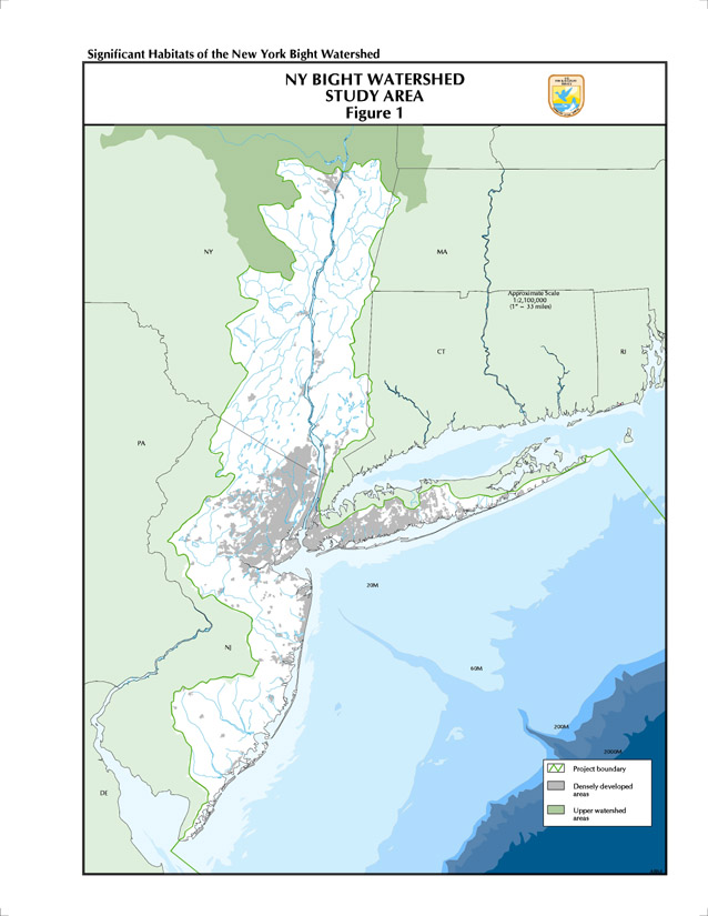
The geographic scope of this habitat assessment includes the estuarine waters of New York - New Jersey Harbor, the tidal waters of the Hudson River from the southern tip of Manhattan Island to the Troy Dam, the watersheds of the harbor and tidal Hudson, and the direct New York Bight upland drainages of New Jersey and southern Long Island. The watershed lands and waters of the New York Bight within this report encompass 20 million acres, or 31,276 square miles, of natural habitats ranging from the deep marine zone at the edge of the continental shelf, through estuarine waters and tidal and freshwater wetlands, to upland regions varied in natural landscape features.
Data acquisition and analysis efforts focused on selected species, referred to in this report as species of special emphasis, including federal trust species and species of significant recreational, commercial, ecological, or biodiversity value to the study region. In order to more thoroughly consider the conservation of regional biological diversity in the study area, data were obtained, compiled, and analyzed on species and habitats of particular concern to the federal government and to the states of New York and New Jersey, regardless of federal status, especially those species being closely tracked and monitored by the Natural Heritage Programs and Fish and Wildlife Departments in the two states. Over 1,000 species of special emphasis were identified, including 114 species of invertebrates, 99 species of fish, 31 species of amphibians and reptiles, 232 species of birds, 38 species of mammals, 491 species of vascular plants, and 82 natural communities. There are 25 federally listed species and two candidate species occurring in the New York Bight study area, as well as 147 state-listed species in New Jersey and 131 state-listed species in New York State.
All known and potential sources of biological data on the distribution and status of species of special emphasis and their habitats were contacted, queried, and compiled by the Coastal Ecosystems Program staff. In addition to species data, background information such as surficial and bedrock geology, coastline, hydrology, physiography, wetlands, land use, and existing managed areas was collected. Much of this information was entered into a computerized geographic information system (GIS) for storage, analysis, and display. Using computer-generated GIS maps and overlays, available data on site locations and occurrences of species and communities of special emphasis in the New York Bight were graphically portrayed for further analysis at appropriate scales that best served to portray their patterns of occurrences in the project region and relationship to landscape features. These findings are the basis for the regional rankings developed for each species, and for the identification, prioritization, and delineation on maps for further analysis of specific habitat areas where species occur. Additional analyses included a determination of the extant population and current status of those specific habitat sites, refinement of site boundaries, linkages between habitats, field validation of data, and actual map delineation of significant habitat areas and complexes of individual sites.
The analysis of habitat data resulted in the identification of 35 large, landscape-scale habitat complexes, such as barrier beaches and coastal lagoons, unfragmented continuous blocks of forest or wetland areas, pine barrens, and freshwater tidal marshes, in the watershed study area. These larger units contain individual habitat units identified by various sources as important to a single species, multiple species, or communities. Final maps and map overlays were prepared at a scale of 1:100,000 for the 35 identified habitat complexes, and site narratives for each area were prepared. These site narratives describe for each complex the location and boundaries, the ecological communities and processes, the various habitat subunits incorporated within the boundary design, the general ownership or protected status, and the ecological significance or uniqueness, particularly regarding species of special emphasis; in addition, site narratives assess threats to the long-term integrity, both to species populations and the physical structure of the habitat, and recommend conservation considerations and protection/restoration strategies. The report's overview chapters discuss physiographic regions, marine zones, regionally significant populations, species groups, and natural communities.
The New York Bight watershed exhibits extraordinary physiographic diversity and geological complexity which, along with climatic and historical events, have contributed directly to the region's remarkable biological diversity and the current distribution patterns of its biota. The study area contains parts of five major physiographic provinces and contains both glaciated and unglaciated regions. The Bight and its adjacent shorelands and uplands within the watershed are rich in living resources, including over 20 species of colonial nesting waterbirds, significant concentrations of wintering waterfowl, critical migratory shorebird concentration areas, spawning and nursery areas for anadromous fish, and rare wetland and upland communities and plants. These resources are considerably lessened from their former abundance and their habitats greatly reduced in extent, making the protection of remaining areas critical to maintaining the biodiversity of the region. The New York City metropolitan area, the financial and commercial center of the country and one of the most populous and heavily industrialized coastal areas in the world, is at the heart of this ecosystem, an ecosystem subject to extreme social and economic use impairments and severe ecological impacts as a result of current and past human activities. Despite these severe environmental stresses and loss of habitats, the New York Bight and its adjacent shorelands and uplands within the watershed continue to be rich in living resources, many of which are of significant economic and social value to the 20 million people living in the region.
Return to table of contents