


formerly the National Oceanographic Data Center (NODC)... more on NCEI
|
|
|
formerly the National Oceanographic Data Center (NODC)... more on NCEI |
|
NCEI is transitioning to a new website and paths to data resources will be changing. Please contact NCEI.Info@noaa.gov with any questions of issues. See the new website at www.ncei.noaa.gov.
| You are here: Home > Ocean Climate Laboratory > OCL Products > Mixed Layer Depths |
|
Mixed Layer Depths by Grigory Monterey, Sydney Levitus | |||||||||||||||||||||||||||||||||||||||
|
| |||||||||||||||||||||||||||||||||||||||
| The MLD fields available are computed from climatological monthly mean profiles of potential temperature and potential density based on three different criteria: a temperature change from the ocean surface of 0.5 degree Celsius, a density change from the ocean surface of 0.125 (sigma units), and a variable density change from the ocean surface corresponding to a temperature change of 0.5 degree Celsius. The MLD based on the variable density criterion is designed to account for the large variability of the coefficient of thermal expansion that characterizes seawater. | |||||||||||||||||||||||||||||||||||||||
|
| |||||||||||||||||||||||||||||||||||||||
Monthly mean MLD data files based on different criteria. (MLD is in meters). The difference between the MLD based on the temperature criterion 0.5 degree Celsius and the MLD based on the variable density criterion can be downloaded. | |||||||||||||||||||||||||||||||||||||||
| |||||||||||||||||||||||||||||||||||||||
|
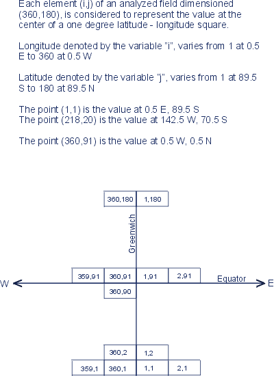
The following co-ordinate system for reading the data was used. Also, see the sample of FORTRAN program anlyxyz.for, which reads in the MLD data file and writes it out to a file in "longitude, latitude, value" format (comma or space delimiting). Use a DOS executable version anlyxyz.exe, which can be run in the DOS window of most any Windows machine. The program designed to reformat the data into a format readable by most spreadsheets, GIS software, mathematical packages, etc. | |||||||||||||||||||||||||||||||||||||||
|
For additional information about these fields the reference is: Monterey, G. and Levitus, S., 1997: Seasonal Variability of Mixed Layer Depth for the World Ocean. NOAA Atlas NESDIS 14, U.S. Gov. Printing Office, Wash., D.C., 96 pp. 87 figs. (pdf, 13.0 MB). |
| Last modified: Thu, 23-Apr-2015 19:57 UTC | NCEI.info@noaa.gov | ||
|
Freedom of Information Act (FOIA)
USA.gov - The U.S. Government's Web Portal
|
|||