NOAA Logo National Centers for Environmental Information

formerly the National Oceanographic Data Center (NODC)...  more on NCEI

NOAA Satellite and Information Service

NCEI is transitioning to a new website and paths to data resources will be changing. Please contact NCEI.Info@noaa.gov with any questions of issues. See the new website at www.ncei.noaa.gov.


CRUISE INFORMATION RECORD (Also available in csv format)
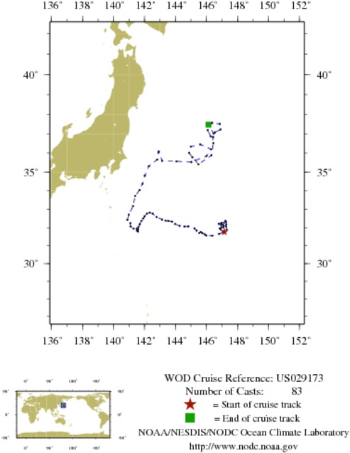
NODC Cruise US-29173 Information
WOD CRUISE REFERENCEUS029173
COUNTRYUNITED STATES (US)
NODC ACCESSION NUMBER (PFL)2352
NODC ACCESSION NUMBER (PFL)33660
NODC ACCESSION NUMBER (PFL)67581
NODC ACCESSION NUMBER (PFL)42682
NODC ACCESSION NUMBER (PFL)2736
PROJECT (2352)U.S. ARGO PROJECT
PROJECT (33660)U.S. ARGO PROJECT
PROJECT (67581)U.S. ARGO PROJECT
PROJECT (42682)U.S. ARGO PROJECT
PROJECT (2736)U.S. ARGO PROJECT
ORIGINATORS CRUISE CODE (PFL)Q2900155
PRIMARY INVESTIGATORS 
All ParametersHACKER; PETER
All ParametersQIU; BO
SUBMITTING INFORMATION (2352) 
SUBMISSION DATE8/10/2005
SUBMITTING INFORMATION (33660) 
SUBMISSION DATE10/3/2007
SUBMITTING INFORMATION (67581) 
SUBMISSION DATE10/4/2010
SUBMITTING INFORMATION (42682) 
SUBMISSION DATE8/5/2008
DATE OF FIRST CAST6/22/2004
DATE OF LAST CAST8/ 6/2005
TOTAL NUMBER OF CASTS83
Temperature [t] PROFILES83
Salinity [s] PROFILES83
Pressure [w] PROFILES83
CASTLATITUDELONGITUDEDATETIMEVARIABLES MEASURED
1038119031.763147.1486/22/20040.516tsw
1038174331.899146.9146/27/20040.656tsw
1038229531.955146.8547/2/20040.000tsw
1038288532.204146.7847/7/20040.234tsw
1038343232.261146.9637/11/200423.625tsw
1038401732.189146.9927/16/200423.766tsw
1053267532.133147.1017/21/200423.625tsw
1038511232.175147.2757/26/200423.813tsw
1038563832.317147.2548/1/20040.328tsw
1038620632.378147.2118/6/20040.516tsw
1038676232.271147.1208/10/200423.859tsw
1038734832.153146.9258/16/20040.047tsw
1038792832.020146.9558/20/200423.813tsw
1038851432.004147.0898/26/20040.047tsw
1038910832.108147.0988/31/20040.703tsw
1038973232.065147.2569/5/20040.797tsw
1039033131.885147.3069/10/20040.234tsw
1039095431.735147.0619/15/20040.375tsw
1039157531.653146.8109/19/200423.813tsw
1039221631.554146.3509/24/200423.906tsw
1039286531.568145.9799/29/200423.766tsw
1053404831.625145.88710/4/200423.906tsw
1039416931.696145.72910/10/20040.563tsw
1039481731.757145.62710/15/20040.609tsw
1039547331.705145.52310/20/20040.047tsw
1039611331.834145.36410/25/20040.188tsw
1039676831.950145.21710/29/200423.672tsw
1039742832.065144.82411/3/200423.719tsw
1039812132.059144.56811/8/200423.578tsw
1039878432.095144.26011/13/200423.766tsw
1039948532.201143.96211/19/20040.375tsw
1040016232.326143.77111/24/20040.422tsw
1040086032.373143.52611/28/200423.906tsw
1040153332.383143.35512/4/20040.516tsw
1040223032.435143.13112/8/200423.766tsw
1040293932.584142.77212/13/200423.625tsw
1040367132.761142.53212/19/20040.703tsw
1040436432.817142.33312/23/200423.484tsw
1040513432.766142.15812/29/20040.234tsw
1040584732.620142.0001/3/20050.234tsw
1040659332.495141.9081/7/200523.719tsw
1040731132.372141.7991/12/200523.766tsw
1040803232.180141.6841/17/200523.391tsw
1040872232.028141.6011/22/200523.859tsw
1040942031.941141.4991/28/20050.516tsw
1041011231.902141.5922/2/20050.516tsw
1041078531.786141.5842/7/20050.047tsw
1053707731.832141.5072/12/20050.047tsw
1053790831.941141.2972/16/200523.672tsw
1053873132.056141.1022/21/200523.578tsw
1053958732.245141.0862/27/20050.797tsw
1054041932.423140.8923/3/200523.719tsw
1054126832.702140.9823/9/20050.328tsw
1054210533.180141.2573/14/20050.281tsw
1054295733.720141.3943/18/200523.906tsw
1054378734.033141.6793/23/200523.813tsw
1054466234.372141.8603/28/200523.531tsw
1054550934.809142.0234/3/20050.000tsw
1054636135.308142.2754/8/20050.656tsw
1054720835.658142.8154/12/200523.578tsw
1054810236.051142.9044/18/20050.141tsw
1054894336.082142.9174/23/20050.094tsw
1054985135.584143.1314/27/200523.625tsw
1055072135.562144.0615/2/200523.578tsw
1055163135.528145.0205/8/20050.891tsw
1055247035.836145.9935/12/200523.766tsw
1055340136.199146.2855/18/20050.422tsw
1055427436.452145.5925/23/20050.281tsw
1055523436.337144.9795/27/200523.859tsw
1055607936.009144.8816/1/200523.859tsw
1055705235.779145.0856/6/200523.625tsw
1055795935.410145.4816/12/20050.094tsw
1055896735.882146.3196/17/20050.703tsw
1055988836.515146.4446/21/200523.719tsw
1056091136.825146.4116/27/20050.234tsw
1056183937.075146.5457/2/20050.047tsw
1056284137.223146.8997/6/200523.766tsw
1056377737.511146.8507/11/200523.766tsw
1056480237.562146.3627/17/20050.984tsw
1056573637.188146.0737/21/200523.859tsw
1056675836.859146.2767/27/20050.469tsw
1059355737.016146.4628/1/20050.281tsw
1059459137.471146.1228/6/20050.000tsw


  Last modified:    Fri, 29-Jun-2018 17:49 UTC NCEI.info@noaa.gov
 
Dept. of Commerce - NOAA - NESDIS - NCEI
* Offsite Link Notification
USA.gov - The U.S. Government's Web Portal