NOAA Logo National Centers for Environmental Information

formerly the National Oceanographic Data Center (NODC)...  more on NCEI

NOAA Satellite and Information Service

NCEI is transitioning to a new website and paths to data resources will be changing. Please contact NCEI.Info@noaa.gov with any questions of issues. See the new website at www.ncei.noaa.gov.


CRUISE INFORMATION RECORD (Also available in csv format)
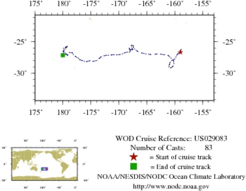
NODC Cruise US-29083 Information
WOD CRUISE REFERENCEUS029083
COUNTRYUNITED STATES (US)
NODC ACCESSION NUMBER (PFL)2352
NODC ACCESSION NUMBER (PFL)33660
NODC ACCESSION NUMBER (PFL)2736
NODC ACCESSION NUMBER (PFL)10599
NODC ACCESSION NUMBER (PFL)13024
PROJECT (2352)U.S. ARGO PROJECT
PROJECT (33660)U.S. ARGO PROJECT
PROJECT (2736)U.S. ARGO PROJECT
PROJECT (10599)U.S. ARGO PROJECT
PROJECT (13024)U.S. ARGO PROJECT
ORIGINATORS CRUISE CODE (PFL)Q5900551
PRIMARY INVESTIGATORS 
All ParametersRISER; STEVE
SUBMITTING INFORMATION (2352) 
SUBMISSION DATE8/10/2005
SUBMITTING INFORMATION (33660) 
SUBMISSION DATE10/3/2007
SUBMITTING INFORMATION (13024) 
SUBMISSION DATE1/25/2007
DATE OF FIRST CAST4/18/2004
DATE OF LAST CAST10/22/2006
TOTAL NUMBER OF CASTS83
Temperature [t] PROFILES83
Salinity [s] PROFILES83
Pressure [w] PROFILES83
CASTLATITUDELONGITUDEDATETIMEVARIABLES MEASURED
10375081-26.690-158.9824/18/20048.297tsw
10375874-26.402-158.9144/28/200422.313tsw
10376717-26.305-158.8895/9/200410.922tsw
10377744-26.387-158.9455/20/20041.266tsw
10378743-26.505-159.0585/30/200412.375tsw
10379861-26.675-159.1456/10/20042.297tsw
10381037-26.833-159.3486/20/200415.469tsw
10382212-27.038-159.5557/1/20044.922tsw
10383415-27.448-159.7907/11/200417.016tsw
10384595-27.803-160.0647/22/20046.656tsw
10385724-28.011-160.5488/1/200419.313tsw
10386931-28.286-160.8358/12/20049.094tsw
10388171-28.643-160.9548/22/200420.203tsw
10389419-28.998-161.0379/2/200411.109tsw
10390700-29.179-160.7409/13/20040.984tsw
10392031-28.968-160.3749/23/200412.094tsw
10393383-28.489-160.14310/4/20040.328tsw
10394774-28.066-160.20410/14/200414.859tsw
10396140-27.631-160.64710/25/20043.047tsw
10397542-27.214-161.15211/4/200416.500tsw
10398968-27.086-161.80711/15/20044.359tsw
10400425-26.985-162.54911/25/200418.047tsw
10401855-26.994-163.36112/6/20047.781tsw
10403368-27.042-164.34412/16/200420.438tsw
10404890-26.952-165.15912/27/20048.344tsw
10406440-26.797-165.9251/6/200523.016tsw
10407969-26.523-166.6901/17/200510.875tsw
10409429-26.162-167.1851/28/20050.047tsw
10536362-25.871-167.4052/7/200512.703tsw
10538121-25.621-167.4152/18/20052.672tsw
10539912-25.550-167.7272/28/200515.516tsw
10541676-25.708-167.7703/11/20055.203tsw
10543450-26.008-167.6743/21/200517.438tsw
10545235-26.179-167.5154/1/20056.469tsw
10547023-26.251-167.5684/11/200520.156tsw
10548823-26.276-167.7214/22/20058.109tsw
10550711-26.266-167.8575/2/200520.578tsw
10552565-26.196-168.0695/13/200510.078tsw
10554491-26.028-168.1385/24/20051.219tsw
10556410-26.047-168.1416/3/200512.281tsw
10558381-26.268-168.0246/14/20050.609tsw
10560435-26.486-167.9836/24/200514.109tsw
10562487-26.686-168.1217/5/20053.188tsw
10564554-26.665-168.4557/15/200516.641tsw
10566614-26.758-168.9087/26/20056.047tsw
10594556-26.938-169.3748/5/200518.375tsw
10596668-27.065-169.8338/16/20057.266tsw
10598762-27.099-170.4058/26/200519.828tsw
10600842-27.087-170.8619/6/20059.188tsw
10602952-27.110-171.3369/16/200521.797tsw
10605136-27.165-171.8429/27/200511.156tsw
10607221-27.171-172.31810/8/20050.563tsw
10609393-27.266-172.64910/18/200513.594tsw
10611532-27.421-173.18710/29/20052.063tsw
10613788-27.644-173.46311/8/200515.141tsw
10616082-28.010-173.94911/19/20053.750tsw
10618457-28.134-174.63511/29/200520.063tsw
10620789-28.036-175.20112/10/20056.750tsw
10623176-28.179-175.79012/20/200519.266tsw
10625527-28.127-176.17312/31/20057.969tsw
10627941-27.989-176.6411/10/200622.219tsw
10630340-27.869-177.0261/21/200610.172tsw
10632816-27.654-177.2042/1/20061.031tsw
10635344-27.369-177.7702/11/200612.188tsw
10637945-27.058-178.1482/22/20063.750tsw
10640469-26.748-178.3553/4/200613.875tsw
10643065-26.738-178.8603/15/20063.000tsw
10645650-27.145-179.1543/25/200615.891tsw
10648223-27.117-179.2554/5/20065.719tsw
10650762-27.074-179.2314/15/200618.281tsw
10653231-26.975-179.3454/26/20067.078tsw
10655746-26.956-179.4025/6/200620.625tsw
10772747-27.064-179.5747/9/20062.344tsw
10775324-26.820-179.6257/19/200615.047tsw
10777896-26.537-179.9657/30/20064.125tsw
10780490-26.034-179.8978/9/200616.875tsw
10783089-25.882-179.5748/20/20066.000tsw
10785677-25.751-179.2668/30/200618.984tsw
10788291-25.911-179.3689/10/20068.719tsw
10790910-26.029-179.5199/20/200623.813tsw
10817434-26.207-179.67210/1/20069.984tsw
10820235-27.003179.96410/12/20061.453tsw
10822985-27.168179.97710/22/200611.953tsw


  Last modified:    Fri, 29-Jun-2018 17:56 UTC NCEI.info@noaa.gov
 
Dept. of Commerce - NOAA - NESDIS - NCEI
* Offsite Link Notification
USA.gov - The U.S. Government's Web Portal