NOAA Logo National Centers for Environmental Information

formerly the National Oceanographic Data Center (NODC)...  more on NCEI

NOAA Satellite and Information Service

NCEI is transitioning to a new website and paths to data resources will be changing. Please contact NCEI.Info@noaa.gov with any questions of issues. See the new website at www.ncei.noaa.gov.


CRUISE INFORMATION RECORD (Also available in csv format)
NODC Cruise US-28865 Information
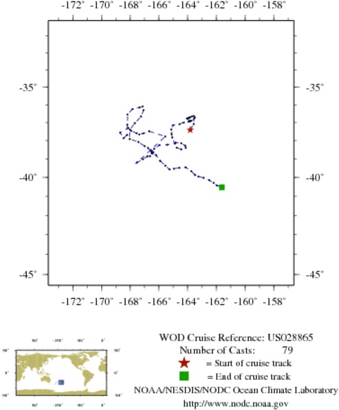
WOD CRUISE REFERENCEUS028865
COUNTRYUNITED STATES (US)
NODC ACCESSION NUMBER (PFL)42682
NODC ACCESSION NUMBER (PFL)2352
NODC ACCESSION NUMBER (PFL)33660
NODC ACCESSION NUMBER (PFL)37967
NODC ACCESSION NUMBER (PFL)2736
INSTITUTE (2352)UNIVERSITY OF WASHINGTON; SEATTLE
PROJECT (42682)U.S. ARGO PROJECT
PROJECT (2352)U.S. ARGO PROJECT
PROJECT (33660)U.S. ARGO PROJECT
PROJECT (37967)U.S. ARGO PROJECT
PROJECT (2736)U.S. ARGO PROJECT
ORIGINATORS CRUISE CODE (PFL)Q5900411
PRIMARY INVESTIGATORS 
All ParametersRISER; STEVE
SUBMITTING INFORMATION (42682) 
SUBMISSION DATE8/5/2008
SUBMITTING INFORMATION (2352) 
SUBMISSION DATE8/10/2005
SUBMITTING INFORMATION (33660) 
SUBMISSION DATE10/3/2007
SUBMITTING INFORMATION (37967) 
SUBMISSION DATE1/25/2008
DATE OF FIRST CAST7/25/2003
DATE OF LAST CAST12/ 5/2005
TOTAL NUMBER OF CASTS79
Temperature [t] PROFILES79
Salinity [s] PROFILES79
Pressure [w] PROFILES79
CASTLATITUDELONGITUDEDATETIMEVARIABLES MEASURED
9908971-37.404-163.8207/25/20039.797tsw
9909705-37.077-163.5778/4/200323.391tsw
9910459-36.781-163.5668/15/200311.766tsw
9911209-36.718-163.5008/26/20031.594tsw
9911979-36.633-163.5669/5/200314.531tsw
9912740-36.656-163.7039/16/20032.813tsw
9913516-36.700-163.8599/26/200315.844tsw
9914292-36.719-163.85110/7/20035.203tsw
9915125-36.762-163.98910/17/200320.719tsw
9915927-36.775-164.04310/28/20036.797tsw
9916748-36.783-163.97311/7/200319.828tsw
9917532-36.897-163.88211/18/20038.859tsw
10363365-36.928-163.81911/28/200321.703tsw
10364186-36.891-163.74912/9/200310.969tsw
10365008-36.945-163.95112/19/200323.906tsw
10365856-36.995-164.27812/30/200312.844tsw
10366711-37.085-164.5701/10/20042.578tsw
10367582-37.144-165.0241/20/200415.375tsw
10368465-37.381-165.1421/31/20043.797tsw
10369397-37.636-165.1122/10/200417.063tsw
10370329-37.827-165.0732/21/20048.906tsw
10529142-38.157-164.9013/2/200418.938tsw
10372156-38.389-164.7633/13/20048.203tsw
10373105-38.476-164.4503/23/200420.906tsw
10373993-38.400-164.1414/3/200410.500tsw
10374759-38.275-164.1674/13/200423.109tsw
10375557-38.149-164.4524/24/200412.516tsw
10376360-38.115-164.8315/5/20042.391tsw
10377321-38.227-165.4105/15/200417.063tsw
10378321-38.250-165.9685/26/20043.422tsw
10379379-38.449-166.3286/5/200416.406tsw
10380527-38.619-166.5276/16/20045.766tsw
10381716-38.689-166.4386/26/200418.188tsw
10382924-38.518-166.5647/7/20047.688tsw
10384124-38.639-166.4017/17/200420.344tsw
10385268-38.703-166.5007/28/20048.813tsw
10386453-38.855-166.6158/8/20041.078tsw
10387653-38.857-166.7948/18/200410.734tsw
10388876-39.013-167.1138/29/20040.469tsw
10390153-39.200-167.5299/8/200412.891tsw
10396977-37.772-165.55810/31/20048.672tsw
10398381-37.484-166.67911/10/200417.531tsw
10399827-37.605-167.09011/21/20049.188tsw
10401257-37.663-167.36812/1/200421.656tsw
10402714-37.591-167.55312/12/200411.203tsw
10404224-37.461-167.93212/23/20040.141tsw
10405796-37.291-168.1381/2/200512.938tsw
10407321-37.561-168.7011/13/20051.125tsw
10408833-37.865-168.4611/23/200514.156tsw
10410289-37.682-168.2192/3/20053.844tsw
10537391-37.124-168.1992/13/200516.453tsw
10539135-36.545-168.1822/24/20055.438tsw
10540920-36.238-167.8423/6/200520.719tsw
11281575-36.157-167.3533/17/20057.828tsw
10544488-36.101-167.1403/27/200520.531tsw
10546263-36.306-167.0724/7/20058.859tsw
10548112-36.660-167.2434/18/20051.359tsw
10549939-37.032-167.6764/28/200510.875tsw
10551815-37.394-168.0195/9/20050.703tsw
10553713-37.913-168.0305/19/200513.500tsw
10555638-38.076-167.4225/30/20053.375tsw
10557560-38.305-166.9876/9/200515.891tsw
10559584-38.407-166.7596/20/20054.359tsw
10561627-38.614-166.4846/30/200517.063tsw
10563672-38.807-166.1877/11/20059.188tsw
10565713-39.104-165.9177/21/200519.172tsw
10593624-39.363-165.5468/1/20057.875tsw
10595759-39.563-165.2708/11/200521.422tsw
10597836-39.531-164.9598/22/20059.844tsw
10599968-39.480-164.5819/1/200523.953tsw
10602049-39.454-164.1409/12/200511.859tsw
10604201-39.666-163.7469/23/20051.125tsw
10606339-39.869-163.48110/3/200516.734tsw
10608471-39.952-163.25910/14/20052.859tsw
10610669-40.022-162.89010/24/200516.781tsw
10612846-40.152-162.49811/4/20054.875tsw
10615147-40.289-162.19811/14/200520.766tsw
10617447-40.431-161.96111/25/20057.266tsw
10619780-40.524-161.61212/5/200519.922tsw


  Last modified:    Fri, 29-Jun-2018 18:08 UTC NCEI.info@noaa.gov
 
Dept. of Commerce - NOAA - NESDIS - NCEI
* Offsite Link Notification
USA.gov - The U.S. Government's Web Portal