NOAA Logo National Centers for Environmental Information

formerly the National Oceanographic Data Center (NODC)...  more on NCEI

NOAA Satellite and Information Service

NCEI is transitioning to a new website and paths to data resources will be changing. Please contact NCEI.Info@noaa.gov with any questions of issues. See the new website at www.ncei.noaa.gov.


CRUISE INFORMATION RECORD (Also available in csv format)
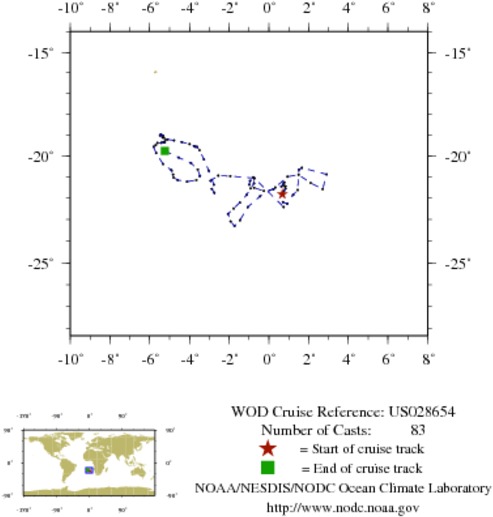
NODC Cruise US-28654 Information
WOD CRUISE REFERENCEUS028654
COUNTRYUNITED STATES (US)
NODC ACCESSION NUMBER (PFL)49897
NODC ACCESSION NUMBER (PFL)42682
NODC ACCESSION NUMBER (PFL)47147
PROJECT (49897)U.S. ARGO PROJECT
PROJECT (42682)U.S. ARGO PROJECT
PROJECT (47147)U.S. ARGO PROJECT
ORIGINATORS CRUISE CODE (PFL)Q5900200
PRIMARY INVESTIGATORS 
All ParametersOWENS; BRECK
SUBMITTING INFORMATION (49897) 
SUBMISSION DATE1/23/2009
SUBMITTING INFORMATION (42682) 
SUBMISSION DATE8/5/2008
SUBMITTING INFORMATION (47147) 
SUBMISSION DATE11/12/2008
DATE OF FIRST CAST5/15/2002
DATE OF LAST CAST4/12/2005
TOTAL NUMBER OF CASTS83
Temperature [t] PROFILES83
Salinity [s] PROFILES83
Pressure [w] PROFILES83
CASTLATITUDELONGITUDEDATETIMEVARIABLES MEASURED
10518193-21.8140.6835/15/200219.359tsw
10518319-21.6720.7595/25/200218.938tsw
10518450-21.5540.8376/4/200219.969tsw
10518578-21.4420.8416/14/200221.188tsw
10518699-21.4370.8076/24/200220.578tsw
10518840-21.3830.7197/4/200223.813tsw
10518981-21.2820.7537/14/200221.188tsw
10519126-21.2580.7767/25/20021.125tsw
10519267-21.4500.6328/4/20020.938tsw
10519415-21.5840.2328/14/20020.844tsw
9889696-21.659-0.2498/24/20020.656tsw
9890161-21.513-0.7409/3/20020.516tsw
9890631-21.364-0.9819/13/20020.375tsw
9891109-21.189-0.9479/23/20020.188tsw
9891574-21.017-0.78810/3/20020.047tsw
9892036-21.070-0.73910/13/20021.500tsw
9892518-21.306-0.74810/23/20021.313tsw
9893007-21.543-0.92111/2/20021.172tsw
9893478-21.847-1.12211/12/20021.172tsw
9893969-22.210-1.45811/22/20022.484tsw
9894460-22.481-1.77412/2/20022.297tsw
9894969-22.735-2.05812/12/20022.250tsw
9895485-23.087-1.92512/22/20023.703tsw
9895988-23.302-1.7271/1/20033.516tsw
9896485-23.034-1.4531/11/20033.375tsw
9897007-22.418-1.0591/21/20036.047tsw
9897548-21.917-0.4471/31/20035.484tsw
9898135-21.4950.3232/10/20034.969tsw
9898742-20.9900.9402/20/20035.953tsw
9899348-20.8921.4983/2/20035.438tsw
9900639-21.2872.1103/22/20037.594tsw
9901918-21.5712.7134/11/200312.469tsw
9903219-20.8762.9085/1/200313.688tsw
9906534-20.5671.6626/20/200318.188tsw
9907218-20.6521.5146/30/200317.578tsw
9912204-21.6151.4509/9/20031.734tsw
9912947-21.8471.2189/19/20033.234tsw
9915225-22.2660.92210/19/20035.063tsw
9916004-22.1850.71210/29/20036.234tsw
10368178-22.4170.7461/27/200421.047tsw
10369931-21.055-0.7292/16/200421.844tsw
10370785-20.961-1.9372/26/200421.375tsw
10371653-20.939-2.5503/7/200421.000tsw
10372546-21.186-2.9323/17/200422.125tsw
10373439-21.567-2.8653/27/200421.797tsw
10374241-21.748-2.7424/6/200422.875tsw
10374980-21.367-2.7654/17/20040.141tsw
10375740-20.698-3.0274/26/200423.672tsw
10376499-20.166-3.2675/7/20041.453tsw
10377438-19.733-3.4945/17/20040.469tsw
10378412-19.571-3.6115/27/20041.031tsw
10379423-19.567-3.6856/6/20042.438tsw
10380524-19.527-3.7676/16/20042.203tsw
10381632-19.439-3.9876/26/20043.703tsw
10382767-19.342-4.3797/6/20043.469tsw
10383932-19.262-4.7757/16/20043.375tsw
10385040-19.212-5.0997/26/200410.078tsw
10386129-19.125-5.3518/5/20049.609tsw
10387271-19.022-5.4818/15/20049.141tsw
10388429-18.973-5.4348/25/20048.766tsw
10389652-19.031-5.3279/4/20049.891tsw
10390874-19.132-5.2909/14/20049.422tsw
10392147-19.229-5.2069/24/20049.000tsw
10393443-19.347-5.23710/4/20048.625tsw
10394744-19.361-5.26110/14/20049.703tsw
10396032-19.331-5.29710/24/20049.281tsw
10397383-19.378-5.41711/3/200410.406tsw
10398710-19.382-5.60811/13/20049.984tsw
10400094-19.489-5.70211/23/200411.203tsw
10401485-19.571-5.80112/3/200414.250tsw
10402862-19.869-5.67312/13/200411.953tsw
10404314-20.385-5.32812/23/200413.781tsw
10405794-20.681-4.8981/2/200513.594tsw
10407249-20.891-4.8241/12/200513.359tsw
10408676-21.028-4.7911/22/200514.719tsw
10410059-21.145-4.5902/1/200514.484tsw
10537024-21.222-4.1182/11/200515.938tsw
10538690-21.149-3.6522/21/200515.703tsw
10540379-20.955-3.4663/3/200516.922tsw
10542066-20.648-3.5793/13/200516.969tsw
10543763-20.336-3.9243/23/200517.297tsw
10545473-20.077-4.5394/2/200518.328tsw
10547192-19.768-5.2394/12/200519.406tsw


  Last modified:    Fri, 29-Jun-2018 18:07 UTC NCEI.info@noaa.gov
 
Dept. of Commerce - NOAA - NESDIS - NCEI
* Offsite Link Notification
USA.gov - The U.S. Government's Web Portal