NOAA Logo National Centers for Environmental Information

formerly the National Oceanographic Data Center (NODC)...  more on NCEI

NOAA Satellite and Information Service

NCEI is transitioning to a new website and paths to data resources will be changing. Please contact NCEI.Info@noaa.gov with any questions of issues. See the new website at www.ncei.noaa.gov.


CRUISE INFORMATION RECORD (Also available in csv format)
NODC Cruise US-28619 Information
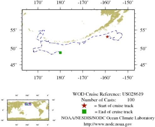
WOD CRUISE REFERENCEUS028619
COUNTRYUNITED STATES (US)
NODC ACCESSION NUMBER (PFL)42682
NODC ACCESSION NUMBER (PFL)927
SHIP NAME (927)UNKNOWN ARGO PROFILING FLOAT
INSTITUTE (42682)US DOC NOAA DATA BUOY CENTER (BAY ST. LOUIS; MS)
INSTITUTE (927)US DOC NOAA DATA BUOY CENTER (BAY ST. LOUIS; MS)
PROJECT (42682)U.S. ARGO PROJECT
ORIGINATORS CRUISE CODE (PFL)Q4900162
PRIMARY INVESTIGATORS 
All ParametersWOODY; CATHERINE
SUBMITTING INFORMATION (42682) 
SUBMISSION DATE8/5/2008
SUBMITTING INFORMATION (927) 
SUBMITTING INSTITUTEMIN OF SCIENTIFIC RES OCEANOGRAPHIC AND FISH RES CENTER (ALEXANDRIA)
DATE OF FIRST CAST1/ 8/2002
DATE OF LAST CAST9/24/2004
TOTAL NUMBER OF CASTS100
Temperature [t] PROFILES100
Salinity [s] PROFILES100
Pressure [w] PROFILES99
CASTLATITUDELONGITUDEDATETIMEVARIABLES MEASURED
988036053.220-159.1071/8/20023.328tsw
988072253.422-158.2901/18/20020.844tsw
988106853.237-157.7241/28/20020.797tsw
988141552.786-157.8282/7/20020.844tsw
988176852.931-157.0622/17/20020.797tsw
988213152.956-156.4332/27/20020.797tsw
988252252.987-156.0883/9/20020.797tsw
988293153.023-155.9373/19/20020.750tsw
988334352.947-156.3513/29/20020.797tsw
988375752.731-156.5544/8/20020.703tsw
1051785952.538-156.6204/18/20023.094tsw
988456452.379-156.3554/28/20020.797tsw
988498352.374-155.7365/8/20020.797tsw
988540752.372-155.1805/18/20020.750tsw
988582252.276-154.6975/28/20020.797tsw
988626052.314-154.0796/7/20020.844tsw
988667052.682-153.5776/17/20020.797tsw
988709653.070-152.9266/27/20020.797tsw
988753053.554-152.4847/7/20020.750tsw
1051900853.846-152.5487/17/20020.750tsw
1051915754.068-152.8727/27/20023.516tsw
988886054.212-153.1918/6/20020.844tsw
988931054.282-153.5698/16/20020.891tsw
988977154.265-153.8498/26/20020.891tsw
989023554.247-154.2779/5/20020.891tsw
989070154.176-154.4549/14/200214.344tsw
989117154.091-154.6399/25/20020.891tsw
989165154.269-154.90010/5/20020.844tsw
989211754.483-154.84710/15/20020.797tsw
989260454.694-154.99610/25/20020.891tsw
989309554.874-155.23511/4/20023.984tsw
989356354.551-156.92311/14/20020.844tsw
989405453.935-159.68511/24/20020.750tsw
989456453.553-162.31912/4/20020.797tsw
989507553.250-165.46312/14/20020.797tsw
989557752.028-168.83412/24/20020.797tsw
989608051.575-169.8101/3/20030.750tsw
989657151.359-169.6911/13/20030.750tsw
989709751.676-168.8801/23/20030.750tsw
989765051.917-169.1732/2/20030.750tsw
989824951.560-171.2802/12/20036.833ts
989884851.051-171.4672/22/20030.797tsw
989945251.487-171.3603/4/20030.703tsw
990009151.731-174.3793/14/20030.750tsw
990073451.157-176.5643/24/20030.750tsw
990136550.976-178.8034/3/20030.938tsw
990200051.338178.4044/13/20030.750tsw
990264651.497177.8254/23/20030.797tsw
990330151.499176.3875/3/20030.750tsw
990395151.526176.2695/13/20030.703tsw
990461251.553175.3215/23/20033.047tsw
990526251.924174.0746/2/20030.703tsw
990593351.935174.7096/12/20030.703tsw
990661252.078174.7076/22/20030.750tsw
990730152.057174.7127/2/20030.938tsw
990799452.018174.7667/12/20031.031tsw
990869452.025174.7227/22/20031.172tsw
990939551.992174.5468/1/20032.531tsw
991010451.987173.7778/11/20030.844tsw
991082852.213172.9928/21/20030.797tsw
991155651.960171.3728/31/20033.516tsw
991227752.621169.5099/10/20030.797tsw
991301653.771170.3109/20/20030.844tsw
991375054.904172.1279/30/20030.750tsw
991449854.056171.44310/10/20030.703tsw
991527354.708170.47710/20/20030.703tsw
991604754.892172.98110/30/20030.750tsw
991682653.765172.25311/9/20030.750tsw
991757252.783171.19511/19/20030.750tsw
1036336651.468171.36711/29/20030.703tsw
1036416150.892171.77312/9/20035.203tsw
1036492550.269171.41012/19/20030.703tsw
1036571450.112169.98012/29/20030.750tsw
1036652250.065168.8511/8/20040.703tsw
1036735249.955168.1271/18/20040.703tsw
1036819349.847167.9271/28/20040.703tsw
1036906349.593167.9632/7/20040.750tsw
1036993949.312168.1422/17/20040.750tsw
1037079649.150168.0522/27/20040.750tsw
1037167249.045168.1623/8/20040.703tsw
1037256548.980168.1983/18/20043.516tsw
1037344849.013168.0963/28/20040.609tsw
1037424849.029168.1644/7/20040.656tsw
1037497848.946168.1964/17/20040.703tsw
1037573048.919168.3994/27/20040.703tsw
1037649548.979168.6485/7/20040.703tsw
1037744349.027169.0995/17/20040.703tsw
1037841749.242169.6585/27/20040.750tsw
1037941849.538170.5366/6/20040.703tsw
1038051049.391172.0396/16/20040.703tsw
1038163949.184173.1226/26/20045.344tsw
1038275449.086173.8307/6/20040.797tsw
1038389348.904174.4527/16/20040.750tsw
1038500848.568175.2347/26/20040.844tsw
1038608848.245176.0178/5/20040.797tsw
1038723548.352176.7698/15/20040.844tsw
1038840148.730177.5768/25/20040.844tsw
1038961449.020178.4839/4/20040.844tsw
1039082449.027179.2999/14/20040.844tsw
1039209548.721-179.9979/24/20040.891tsw


  Last modified:    Fri, 29-Jun-2018 18:09 UTC NCEI.info@noaa.gov
 
Dept. of Commerce - NOAA - NESDIS - NCEI
* Offsite Link Notification
USA.gov - The U.S. Government's Web Portal