NOAA Logo National Centers for Environmental Information

formerly the National Oceanographic Data Center (NODC)...  more on NCEI

NOAA Satellite and Information Service

NCEI is transitioning to a new website and paths to data resources will be changing. Please contact NCEI.Info@noaa.gov with any questions of issues. See the new website at www.ncei.noaa.gov.


CRUISE INFORMATION RECORD (Also available in csv format)
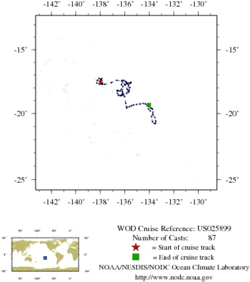
NODC Cruise US-25899 Information
WOD CRUISE REFERENCEUS025899
COUNTRYUNITED STATES (US)
NODC ACCESSION NUMBER (PFL)42682
NODC ACCESSION NUMBER (PFL)67581
NODC ACCESSION NUMBER (PFL)65273
PROJECT (42682)U.S. ARGO PROJECT
PROJECT (67581)U.S. ARGO PROJECT
PROJECT (65273)U.S. ARGO PROJECT
ORIGINATORS CRUISE CODE (PFL)5902190
PRIMARY INVESTIGATORS 
All ParametersROEMMICH; DEAN
SUBMITTING INFORMATION (42682) 
SUBMISSION DATE8/5/2008
SUBMITTING INFORMATION (67581) 
SUBMISSION DATE10/4/2010
SUBMITTING INFORMATION (65273) 
SUBMISSION DATE7/6/2010
DATE OF FIRST CAST9/22/2008
DATE OF LAST CAST1/29/2011
TOTAL NUMBER OF CASTS87
Temperature [t] PROFILES87
Salinity [s] PROFILES87
Pressure [w] PROFILES87
CASTLATITUDELONGITUDEDATETIMEVARIABLES MEASURED
11717344-17.501-137.9989/22/20086.422tsw
11720373-17.655-137.96610/2/20085.766tsw
11723421-17.701-137.86310/12/20085.531tsw
11726531-17.703-137.84310/22/20085.250tsw
11729611-17.738-137.84511/1/20084.969tsw
11732495-17.618-137.84311/11/20084.688tsw
11782371-17.440-137.91011/21/20084.406tsw
11785483-17.322-137.98612/1/20084.125tsw
11788633-17.333-137.94412/11/20083.797tsw
11791756-17.289-137.88612/21/20083.516tsw
11794928-17.332-137.94612/31/20083.281tsw
11798097-17.257-138.1011/10/20093.000tsw
11801155-17.433-138.2621/20/20092.766tsw
11851449-17.623-138.3031/30/20092.484tsw
11854687-17.728-138.0542/9/20092.250tsw
11857953-17.725-137.6402/19/20091.969tsw
11861182-17.594-137.1043/1/20091.734tsw
11864430-17.412-136.6753/11/20091.453tsw
11867661-17.463-136.2593/21/20091.219tsw
11870861-17.779-135.9583/31/20090.938tsw
11905427-18.110-135.8164/10/20090.703tsw
11908699-18.341-135.7074/20/20090.422tsw
11912060-18.275-135.6464/30/20090.188tsw
11915399-17.975-135.5895/10/20091.359tsw
11918678-17.779-135.7115/19/200923.625tsw
11921985-17.682-135.7855/30/20090.797tsw
11925283-17.584-135.8416/9/20090.703tsw
11928533-17.629-135.6666/19/20090.375tsw
11931808-17.610-135.5136/28/200922.547tsw
11935190-17.565-135.5117/8/200922.266tsw
11966191-17.659-135.5837/18/200921.938tsw
11968830-17.591-135.8657/28/200921.656tsw
11971464-17.773-136.0008/7/200921.375tsw
12008605-17.908-136.1658/17/200921.047tsw
11976474-18.301-136.1928/27/200920.766tsw
11979038-18.434-135.8559/6/200920.438tsw
11981599-18.181-135.7139/16/200920.109tsw
12010432-17.826-135.7019/26/200919.828tsw
11986605-17.682-135.84410/6/200919.500tsw
11989109-17.566-135.87410/16/200919.219tsw
11991688-17.502-135.95710/26/200918.891tsw
12012291-17.413-136.09711/5/200918.563tsw
11996640-17.437-136.24711/15/200918.281tsw
12015976-17.456-136.20911/25/200917.953tsw
12019059-17.759-136.26812/5/200917.672tsw
12022112-18.128-136.29212/15/200917.391tsw
12025195-18.489-136.12312/25/200917.063tsw
12307264-18.578-136.1261/4/201016.688tsw
12307265-18.535-136.2441/14/201016.359tsw
12307266-18.625-136.2991/24/201016.172tsw
12307267-18.570-136.2512/3/201015.891tsw
12307268-18.595-136.3992/13/201015.281tsw
12307269-18.588-136.5342/23/201015.047tsw
12307270-18.422-136.6113/5/201014.766tsw
12307271-18.245-136.6163/15/201014.484tsw
12307272-18.229-136.6243/25/201014.203tsw
13059090-18.192-136.6074/4/201013.969tsw
13062089-18.243-136.5364/14/201013.734tsw
13065063-18.243-136.3834/24/201013.500tsw
13068051-18.398-136.1935/4/201013.266tsw
13071083-18.690-136.0235/14/201012.984tsw
13074126-19.203-135.9235/24/201012.797tsw
13077139-19.454-135.8576/3/201012.609tsw
13080129-19.571-135.8486/13/201012.281tsw
13083149-19.469-135.6166/23/201012.000tsw
13161694-19.403-135.4677/3/201011.672tsw
13164769-19.344-135.2897/13/201011.391tsw
13167830-19.297-135.0397/23/201011.156tsw
13170796-19.258-134.7528/2/201010.875tsw
13173739-19.219-134.5108/12/201010.594tsw
13176644-19.245-134.3318/22/201010.313tsw
13179590-19.369-134.1649/1/201010.078tsw
13182519-19.483-134.0219/11/20109.797tsw
13185437-19.574-133.8789/21/20109.516tsw
13188390-19.600-133.78910/1/20109.281tsw
13279865-19.664-133.74110/11/20109.000tsw
13282830-19.892-133.69510/21/20108.719tsw
13285808-20.254-133.81910/31/20108.438tsw
13288801-20.636-133.73111/10/20108.203tsw
13291792-20.757-133.58611/20/20107.922tsw
13294793-20.778-133.50011/30/20107.641tsw
13297788-20.590-133.47012/10/20107.359tsw
13300841-20.319-133.53912/20/20107.078tsw
13303933-20.062-133.70312/30/20106.797tsw
13411880-19.804-133.9121/9/20116.516tsw
13415020-19.653-134.0671/19/20116.234tsw
13418055-19.345-134.0351/29/20115.953tsw


  Last modified:    Fri, 29-Jun-2018 18:02 UTC NCEI.info@noaa.gov
 
Dept. of Commerce - NOAA - NESDIS - NCEI
* Offsite Link Notification
USA.gov - The U.S. Government's Web Portal