NOAA Logo National Centers for Environmental Information

formerly the National Oceanographic Data Center (NODC)...  more on NCEI

NOAA Satellite and Information Service

NCEI is transitioning to a new website and paths to data resources will be changing. Please contact NCEI.Info@noaa.gov with any questions of issues. See the new website at www.ncei.noaa.gov.


CRUISE INFORMATION RECORD (Also available in csv format)
NODC Cruise US-16887 Information
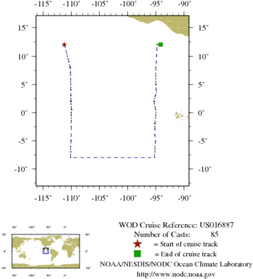
WOD CRUISE REFERENCEUS016887
COUNTRYUNITED STATES (US)
NODC ACCESSION NUMBER (OSD)841
NODC ACCESSION NUMBER (CTD)1364
SHIP NAME (841)KA'IMIMOANA (NOAA ship;R/V;c.s. WTEU;built 1989;ex Titan 1996;IMO8835231)
INSTITUTE (1364)US DOC NOAA ERL PMEL (SEATTLE; WA)
PROJECT (1364)Tropical Atmosphere Ocean (TAO) BUOY ARRAY
ORIGINATORS CRUISE CODE (OSD)33KM200303_1
SUBMITTING INFORMATION (841) 
SUBMISSION DATE7/9/2002
SUBMITTING INFORMATION (1364) 
SUBMITTING INSTITUTEUS DOC NOAA ERL PMEL (SEATTLE; WA)
SUBMITTING INVESTIGATORMcPHADEN; DR. MIKE
SUBMISSION DATE2/25/2004
DATE OF FIRST CAST3/30/2003
DATE OF LAST CAST4/22/2003
TOTAL NUMBER OF CASTS85
Temperature [t] PROFILES85
Salinity [s] PROFILES85
Pressure [w] PROFILES85
CASTLATITUDELONGITUDEDATETIMEVARIABLES MEASURED
991976112.013-111.2133/30/200314.217tsw
1019065511.013-110.9403/30/200322.717tsw
991976211.013-110.9403/30/200322.717tsw
1019065610.007-110.6883/31/20036.917tsw
991976310.007-110.6883/31/20036.917tsw
101906579.003-110.4183/31/200315.400tsw
99197649.003-110.4183/31/200315.400tsw
101906588.052-110.1804/1/20032.133tsw
99197658.052-110.1804/1/20032.133tsw
101906597.003-110.1034/1/200310.883tsw
99197667.003-110.1034/1/200310.883tsw
101906608.055-110.1634/2/20030.167tsw
99197678.055-110.1634/2/20030.167tsw
101906616.005-110.0924/2/200318.917tsw
99197686.005-110.0924/2/200318.917tsw
101906625.023-110.0624/3/20034.267tsw
99197695.023-110.0624/3/20034.267tsw
101906634.013-110.0454/3/200312.483tsw
99197704.013-110.0454/3/200312.483tsw
101906643.002-110.0584/3/200320.267tsw
99197713.002-110.0584/3/200320.267tsw
101906652.505-110.0624/4/20030.833tsw
99197722.505-110.0624/4/20030.833tsw
101906662.062-110.0754/4/20035.717tsw
99197732.062-110.0754/4/20035.717tsw
101906672.050-110.0504/4/200322.717tsw
99197742.050-110.0504/4/200322.717tsw
101906681.508-110.0224/5/20033.617tsw
99197751.508-110.0224/5/20033.617tsw
99197761.003-109.9774/5/20038.267tsw
101906690.513-109.9174/6/20031.283tsw
99197770.513-109.9174/6/20031.283tsw
101906700.010-109.9854/6/20034.333tsw
99197780.010-109.9854/6/20034.333tsw
10190671-0.488-109.9834/7/20032.300tsw
9919779-0.488-109.9834/7/20032.300tsw
10190672-0.993-109.9724/7/20036.900tsw
9919780-0.993-109.9724/7/20036.900tsw
10190673-2.495-109.9904/7/200321.467tsw
9919781-2.495-109.9904/7/200321.467tsw
10190674-4.985-110.0134/8/200315.267tsw
9919782-4.985-110.0134/8/200315.267tsw
10190675-5.995-110.0834/8/200323.867tsw
9919783-5.995-110.0834/8/200323.867tsw
10190676-6.997-110.0704/9/20037.300tsw
9919784-6.997-110.0704/9/20037.300tsw
10190677-7.992-110.0774/10/20030.067tsw
9919785-7.992-110.0774/10/20030.067tsw
9919786-7.990-95.2504/14/20032.483tsw
9919787-7.995-95.2554/14/200317.183tsw
9919788-7.002-95.2034/15/20030.233tsw
9919789-6.003-95.1684/15/20037.400tsw
9919790-5.058-95.0754/15/200321.467tsw
9919791-3.995-95.2234/16/20035.850tsw
9919792-2.998-95.1834/16/200312.983tsw
9919793-2.497-95.1834/16/200317.100tsw
9919794-1.990-95.1824/16/200321.283tsw
9919795-1.980-95.1834/16/200322.183tsw
9919796-1.980-95.1824/16/200323.233tsw
9919797-1.000-95.0804/17/20036.633tsw
99197980.008-94.9904/17/200320.983tsw
99197990.507-95.0404/18/20033.900tsw
99198001.000-95.1624/18/20037.833tsw
99198011.507-95.2504/18/200312.000tsw
99198022.008-95.3454/18/200316.067tsw
99198032.000-95.3434/18/200317.350tsw
99198042.027-95.3404/18/200318.117tsw
99198052.497-95.2184/18/200321.733tsw
99198063.003-95.0904/19/20031.767tsw
99198073.632-94.9454/19/20036.750tsw
99198084.005-94.9504/19/20039.950tsw
99198094.953-94.9904/19/200316.300tsw
99198104.943-94.9934/19/200317.283tsw
99198114.972-94.9934/19/200318.350tsw
99198126.000-94.9904/20/20031.217tsw
99198136.998-95.0624/20/20038.200tsw
99198148.090-95.0004/21/20032.983tsw
99198159.007-94.9434/21/200310.067tsw
991981610.018-94.8884/21/200317.017tsw
991981710.013-94.9004/21/200317.667tsw
991981810.023-94.8924/21/200318.533tsw
991981911.000-94.8504/22/20031.450tsw
991982012.017-94.7854/22/20039.333tsw
991982112.007-94.8234/22/200312.400tsw
991982212.025-94.1634/22/200313.083tsw


  Last modified:    Wed, 12-Jul-2017 16:12 UTC NCEI.info@noaa.gov
 
Dept. of Commerce - NOAA - NESDIS - NCEI
* Offsite Link Notification
USA.gov - The U.S. Government's Web Portal