NOAA Logo National Centers for Environmental Information

formerly the National Oceanographic Data Center (NODC)...  more on NCEI

NOAA Satellite and Information Service

NCEI is transitioning to a new website and paths to data resources will be changing. Please contact NCEI.Info@noaa.gov with any questions of issues. See the new website at www.ncei.noaa.gov.


CRUISE INFORMATION RECORD (Also available in csv format)
NODC Cruise FR-13923 Information
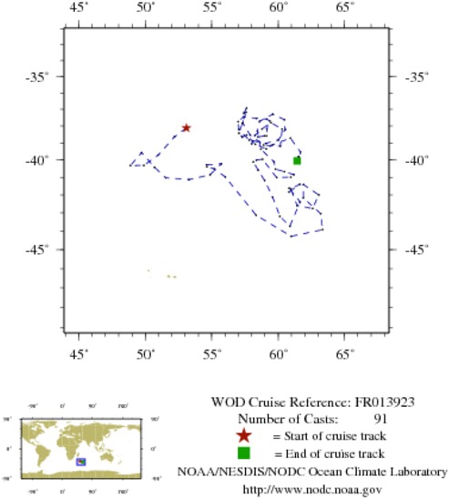
WOD CRUISE REFERENCEFR013923
COUNTRYFRANCE (FR)
NODC ACCESSION NUMBER (PFL)42682
NODC ACCESSION NUMBER (PFL)2352
PROJECT (42682)FLOSTRAL (FLOTTEURS DE L'OCEAN AUSTRAL)
PROJECT (2352)FLOSTRAL (FLOTTEURS DE L'OCEAN AUSTRAL)
ORIGINATORS CRUISE CODE (PFL)Q1900129
PRIMARY INVESTIGATORS 
All ParametersMORROW-GREINER; ROSE-MARY
SUBMITTING INFORMATION (42682) 
SUBMISSION DATE8/5/2008
SUBMITTING INFORMATION (2352) 
SUBMISSION DATE8/10/2005
DATE OF FIRST CAST1/ 9/2003
DATE OF LAST CAST6/27/2005
TOTAL NUMBER OF CASTS91
Temperature [t] PROFILES91
Salinity [s] PROFILES91
Pressure [w] PROFILES91
CASTLATITUDELONGITUDEDATETIMEVARIABLES MEASURED
9896398-38.12953.0941/9/20037.078tsw
9896908-38.65752.1861/19/20037.078tsw
9897447-39.71750.9891/29/20037.219tsw
9898028-40.31949.8872/8/20037.078tsw
9898630-40.32948.8792/18/20037.125tsw
9899242-39.57849.7292/28/20036.703tsw
9899874-40.42650.6943/10/20037.031tsw
9900503-41.03051.5383/20/20037.219tsw
9901151-41.13253.2933/30/20037.125tsw
9901773-40.85654.8694/9/20037.313tsw
9902412-40.22555.7344/19/20037.313tsw
9903054-40.27754.6074/29/20036.797tsw
9903717-40.39954.6465/9/20037.219tsw
9904368-40.52355.1955/19/20037.031tsw
9905022-40.97956.0265/29/20037.219tsw
9905689-43.12858.3366/8/20037.125tsw
9906364-44.27660.9746/18/20037.219tsw
9907063-43.92263.3476/28/20037.219tsw
9907752-43.04463.2027/8/20037.219tsw
9908449-42.16561.8987/18/20037.172tsw
9909148-41.42061.9157/28/20036.750tsw
9909849-41.99163.0588/7/20037.266tsw
9910574-42.76162.5968/17/20037.172tsw
9911302-42.58461.4218/27/20037.266tsw
9912027-41.64860.9579/6/20037.172tsw
9912742-41.40261.6219/16/20037.266tsw
9913499-41.83960.8209/26/20037.266tsw
9914209-41.61860.81910/6/20037.172tsw
9914986-42.38661.65010/16/20037.172tsw
9915759-43.73760.87710/26/20037.453tsw
9916518-43.18960.13311/5/20037.453tsw
9917274-42.12359.58911/15/20037.172tsw
10363051-41.18158.98211/25/20037.453tsw
10363834-40.59958.49612/5/20037.406tsw
10364619-40.11858.13912/15/20037.500tsw
10365419-40.00758.37112/25/20037.406tsw
10366222-39.96658.8221/4/20047.266tsw
10367042-41.01559.8851/14/20047.266tsw
10367886-40.99560.9481/24/20047.266tsw
10368744-40.84761.1792/3/20047.500tsw
10369624-40.68360.4762/13/20047.500tsw
10370501-40.53659.8002/23/20047.313tsw
10371353-40.11859.6913/4/20047.406tsw
10372236-39.37458.7003/14/20047.313tsw
10373141-38.30758.4383/24/20047.219tsw
10529837-37.73158.6024/3/20047.406tsw
10530196-37.30259.5984/13/20047.313tsw
10530565-37.62760.4704/23/20047.313tsw
10530936-38.22460.5335/3/20047.313tsw
10377083-38.83960.0195/13/20047.594tsw
10378051-39.03559.0805/23/20047.500tsw
10378993-38.84357.8166/2/20047.313tsw
10380085-38.21557.0496/12/20047.500tsw
10381210-37.75356.9936/22/20047.406tsw
10382325-37.46257.4077/2/20047.406tsw
10383459-37.55358.3717/12/20047.313tsw
10384598-37.60459.1467/22/20047.453tsw
10385665-37.70359.3538/1/20047.313tsw
10386797-38.18859.1548/11/20047.313tsw
10387966-38.59659.1228/21/20047.453tsw
10389143-38.60158.9678/31/20047.547tsw
10390365-38.66158.4729/10/20047.547tsw
10391618-38.89158.0789/20/20047.547tsw
10392904-39.06758.0079/30/20047.453tsw
10394212-38.55258.25610/10/20047.547tsw
10395514-38.18558.78710/20/20047.641tsw
10396818-37.80859.45710/30/20047.547tsw
10398158-38.19860.30911/9/20047.359tsw
10399532-39.19660.16211/19/20047.453tsw
10400903-39.13358.91511/29/20047.453tsw
10402274-38.54357.89312/9/20047.453tsw
10403715-37.86557.35512/19/20047.359tsw
10405185-37.23257.43112/29/20047.453tsw
10406632-36.93857.6191/8/20057.359tsw
10408091-37.18157.5911/18/20057.453tsw
10535988-37.83457.3071/28/20057.688tsw
10536314-38.43557.0482/7/20057.266tsw
10537964-38.65357.2852/17/20057.500tsw
10539637-38.67657.2912/27/20057.500tsw
10541317-38.54457.6303/9/20057.500tsw
10543016-39.09258.2713/19/20057.500tsw
10544719-39.36659.1063/29/20057.594tsw
10546407-39.11459.5854/8/20057.688tsw
10548157-38.73160.9314/18/20057.500tsw
10549921-39.53961.6814/28/20057.406tsw
10551693-39.96361.5675/8/20057.688tsw
10553465-39.82161.5475/18/20056.703tsw
10555291-39.81561.5685/28/20057.688tsw
10557101-39.85761.4926/7/20057.781tsw
10559028-40.00661.5316/17/20057.078tsw
10560977-40.05361.4276/27/20057.313tsw


  Last modified:    Fri, 29-Jun-2018 17:58 UTC NCEI.info@noaa.gov
 
Dept. of Commerce - NOAA - NESDIS - NCEI
* Offsite Link Notification
USA.gov - The U.S. Government's Web Portal