NOAA Logo National Centers for Environmental Information

formerly the National Oceanographic Data Center (NODC)...  more on NCEI

NOAA Satellite and Information Service

NCEI is transitioning to a new website and paths to data resources will be changing. Please contact NCEI.Info@noaa.gov with any questions of issues. See the new website at www.ncei.noaa.gov.


CRUISE INFORMATION RECORD (Also available in csv format)
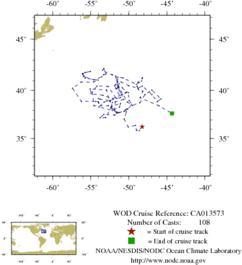
NODC Cruise CA-13573 Information
WOD CRUISE REFERENCECA013573
COUNTRYCANADA (CA)
NODC ACCESSION NUMBER (PFL)2352
NODC ACCESSION NUMBER (PFL)33660
NODC ACCESSION NUMBER (PFL)42682
NODC ACCESSION NUMBER (PFL)37967
PROJECT (2352)CANADIAN ARGO
PROJECT (33660)CANADIAN ARGO
PROJECT (42682)CANADIAN ARGO
PROJECT (37967)CANADIAN ARGO
ORIGINATORS CRUISE CODE (PFL)Q4900233
PRIMARY INVESTIGATORS 
All ParametersFREELAND; H.J.
All ParametersGREENAN; BLAIR
SUBMITTING INFORMATION (2352) 
SUBMISSION DATE8/10/2005
SUBMITTING INFORMATION (33660) 
SUBMISSION DATE10/3/2007
SUBMITTING INFORMATION (42682) 
SUBMISSION DATE8/5/2008
SUBMITTING INFORMATION (37967) 
SUBMISSION DATE1/25/2008
DATE OF FIRST CAST5/23/2002
DATE OF LAST CAST4/27/2005
TOTAL NUMBER OF CASTS108
Temperature [t] PROFILES108
Salinity [s] PROFILES108
Pressure [w] PROFILES108
CASTLATITUDELONGITUDEDATETIMEVARIABLES MEASURED
988565636.254-48.2515/23/20029.469tsw
988607835.842-48.6216/2/20029.469tsw
988648635.880-48.9896/12/20029.328tsw
988692236.398-49.1196/22/200210.359tsw
988734836.224-50.0707/2/20029.938tsw
988776937.078-50.6127/12/20029.328tsw
988822637.826-50.3187/22/200210.453tsw
988867538.116-50.2538/1/20029.797tsw
988911737.479-51.8658/11/20029.328tsw
988957037.555-53.2608/21/20029.563tsw
989003737.196-53.7558/31/20029.469tsw
989051137.225-53.0349/10/200210.500tsw
989098038.400-52.2079/20/200210.500tsw
989145638.699-51.0939/30/20029.656tsw
989191538.302-51.23010/10/20029.422tsw
989240337.976-52.15610/20/20029.422tsw
989287238.320-53.91710/30/20029.938tsw
989335138.832-53.25511/9/20029.375tsw
989382739.305-51.08711/19/20029.281tsw
989433540.170-51.66211/29/20029.891tsw
989484340.516-51.86312/9/200210.078tsw
989534540.610-51.73712/19/20029.750tsw
989585540.465-51.35512/29/20029.469tsw
989634940.286-50.8621/8/20039.328tsw
989686339.866-50.2911/18/20039.703tsw
989740139.763-50.4731/28/20039.703tsw
989798439.808-50.0572/7/20039.984tsw
989857838.995-49.9532/17/20039.234tsw
989918238.494-49.5142/27/20039.750tsw
989981438.764-48.5643/9/20039.234tsw
990043839.613-47.8603/19/20039.281tsw
990109140.060-46.9753/29/20039.750tsw
990170639.153-45.7784/8/200310.125tsw
990234338.878-46.2694/18/20039.703tsw
990299539.590-46.9674/28/20039.656tsw
990365440.459-48.2165/8/200310.219tsw
990431240.249-48.8145/18/20039.469tsw
990495540.481-49.9685/28/20039.563tsw
990562840.852-50.9926/7/20039.703tsw
990630241.593-52.2006/17/200310.031tsw
990700641.842-53.0626/27/20039.469tsw
990769242.028-53.4307/7/200310.547tsw
990838642.184-53.2807/17/200310.031tsw
990908841.662-52.9937/27/200310.406tsw
990979241.589-53.3128/6/20039.984tsw
991051741.385-53.5368/16/20039.516tsw
991124641.080-54.5858/26/200310.500tsw
991196641.416-55.9329/5/20039.844tsw
991267141.634-56.0679/15/20039.797tsw
991342341.817-55.7319/25/200310.031tsw
991414541.915-55.03710/5/200310.266tsw
991490841.717-56.05110/15/20039.703tsw
991567741.247-55.69710/25/20039.516tsw
991644041.050-54.01211/4/20039.422tsw
991720340.870-54.63711/14/20039.609tsw
1036297940.860-56.22711/24/200310.266tsw
1036375340.233-57.37312/4/20039.797tsw
1036453538.902-56.23212/14/20039.094tsw
1036533638.902-54.32112/24/200310.031tsw
1036613238.743-53.9401/3/20049.328tsw
1036695338.858-54.0361/13/20049.375tsw
1036780239.183-53.9991/23/20049.422tsw
1036866539.138-53.7892/2/20049.891tsw
1036954338.972-52.5362/12/20049.234tsw
1037042940.056-52.9042/22/200410.313tsw
1037127540.174-55.0773/3/20049.750tsw
1037216639.682-54.9343/13/200410.359tsw
1037305439.519-53.3893/23/20049.984tsw
1037389439.190-52.1034/2/20049.609tsw
1037463039.614-50.8344/12/200410.078tsw
1037537340.228-51.5494/22/20049.375tsw
1037613040.677-51.2715/2/20049.516tsw
1037699641.021-51.5495/12/20049.516tsw
1037796940.859-51.4725/22/20049.938tsw
1037892140.299-51.2886/1/20049.328tsw
1038000238.833-50.1696/11/20049.703tsw
1038111438.549-49.6456/21/20049.797tsw
1038223138.120-50.1217/1/200410.500tsw
1038337937.868-50.6207/11/20049.938tsw
1038451237.744-51.4027/21/20049.656tsw
1038558438.006-51.9247/31/200410.734tsw
1038670739.213-51.6708/10/200410.078tsw
1038786540.419-52.7208/20/20049.563tsw
1038905440.463-54.1698/30/200411.063tsw
1039025639.846-54.7969/9/20049.938tsw
1039151238.451-54.5539/19/20049.563tsw
1039281138.455-52.6599/29/200411.438tsw
1039409138.974-52.44710/9/20049.703tsw
1039540338.151-52.17610/19/200410.594tsw
1039669137.669-51.55210/29/20049.844tsw
1039804237.827-51.57911/8/20049.563tsw
1039942038.275-52.34911/18/20049.984tsw
1040079738.783-52.14511/28/200410.031tsw
1040215639.110-50.66312/8/20049.422tsw
1040359240.367-51.43512/18/20049.281tsw
1040505441.443-51.71512/28/20049.891tsw
1040650541.333-51.4361/7/20059.281tsw
1053568941.267-50.7461/17/200510.313tsw
1053596940.619-48.9931/27/20059.563tsw
1053625840.978-48.3132/6/200510.406tsw
1053782641.288-48.2072/16/20059.656tsw
1053950040.841-48.7922/26/20059.563tsw
1054119140.433-48.9113/8/20059.797tsw
1054287740.102-48.6953/18/200510.031tsw
1054458239.941-48.1603/28/20059.422tsw
1096210239.277-48.5194/7/20059.188tsw
1096215738.448-46.0454/17/20059.797tsw
1096221537.651-44.3194/27/20059.234tsw


  Last modified:    Fri, 29-Jun-2018 18:04 UTC NCEI.info@noaa.gov
 
Dept. of Commerce - NOAA - NESDIS - NCEI
* Offsite Link Notification
USA.gov - The U.S. Government's Web Portal