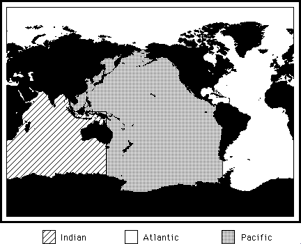
About Ocean Boundary Definitions
The following map shows the definitions of ocean boundaries used to divide the data on the CD. Below the figure are tables giving the coordinates of the boundaries.
 |
| Pacific Ocean |
| Longitude band |
Southern Latitude |
Northern Latitude |
| 070 W - 080 W |
80 deg. S |
9 deg. N |
| 080 W - 084 W |
80 deg. S |
9 deg. N |
| 084 W - 090 W |
80 deg. S |
14 deg. N |
| 090 W - 100 W |
80 deg. S |
18 deg. N |
| 100 W - 145 E |
80 deg. S |
66 deg. N |
| 145 E - 100 E |
0 deg. |
66 deg. N |
|
| |
| Indian Ocean |
| Longitude band |
Southern Latitude |
Northern Latitude |
| 020 E - 100 E |
80 deg. S |
31 deg. N |
| 100 E - 145 E |
80 deg. S |
0 deg. |
|
| |
| Atlantic Ocean |
| Longitude band |
Southern Latitude |
Northern Latitude |
| 100 E - 020 E |
31 deg. N |
90 deg. N |
| 020 E - 070 W |
80 deg. S |
90 deg. N |
| 070 W - 084 W |
09 deg. N |
90 deg. N |
| 084 W - 090 W |
14 deg. N |
90 deg. N |
| 090 W - 100 W |
18 deg. N |
90 deg. N |
| 100 W - 100 E |
66 deg. N |
90 deg. N |
|


 Offsite Link Notification