README

This CDROM is a compilation of Seasoar data collected during the
Subduction Experiment in the Eastern North Atlantic during the period of
May 1991 - May 1993. If you do not have the necessary software to
run Mosaic, view gif files, uncompress files or read NetCDF files, go to
the miscellaneous directory, read the README file
and use the available software, or instructions on how to retrieve the
necessary software.
The CDROM consists of the following, it is the same as the CDROM file
directory structure:
- README - Readme file (same as this without html code)
- REPORT.htm- HTML code and pointers to the accompanying data report
TEXT.htm. Start with this file to view the Data Report using HTML format.
- TEXT.htm - HTML copy of the accompanying data report.
- REPORT.DOC - Text copy of the accompanying data report
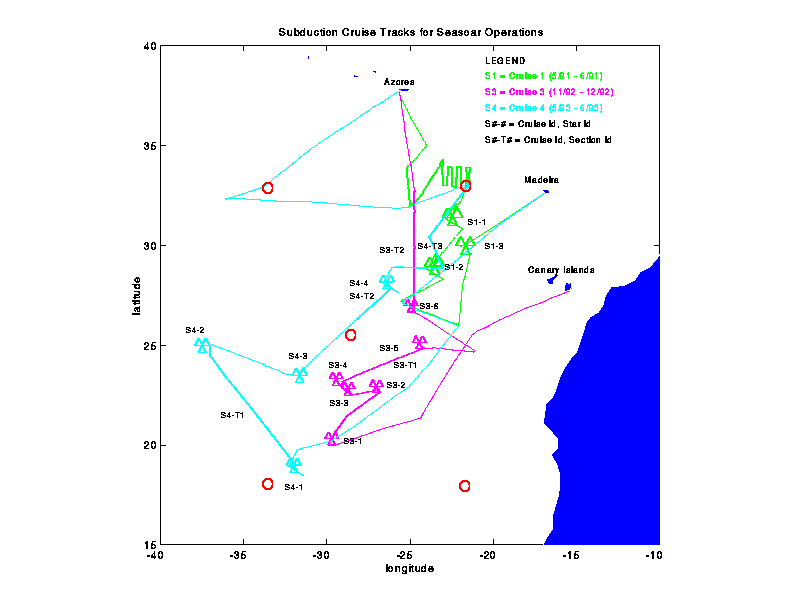
- map.gif - Graphic view of cruise track for the entire experiment
- postscript version
- seasoar.gif - Graphic View of Seasoar
- figure.con - List of Figures and tables referred to in the REPORT.htm
- figure1-9.gif - figures referred to in the REPORT.htm document
- table1-2.doc - tables referred to in the REPORT.htm document
- transect.htm - HTML file corresponding to appendix C of the Data Report
- star.htm - HTML file corresponding to appendix D of the Data Report
- Photos collected during the four cruises
- To view the contents of this directory click here
- Subduction Cruise 1:
- Data - 1 second and 3 second data. They are identified by star
patterns in both matlab (*.mat) and gzip compressed ascii format
(*.asc.gz). The 3 second files are delineated by an _3 added
to the name files. File format is time in Decimal days, pressure,
temperature, Salinity, and Sigma-theta. 1E38 (or NaN in matlab files)
is null value.
- Gif files - Color gif files of sections and star patterns (as shown
in data report in black and white).
Sub1.gif = cruise track for subduction 1.
The files are identifies by star pattern name, plus an underscore
with a number identifying the density surface of interest, and
a letter to identify the property mapped on that density surface.
	 _5 = 26.5 density surface
	 _7 = 26.7 density surface
	 _9 = 26.9 density surface
	 _5p = pressure on density surface 26.5
	 _5t = Theta on density surface 26.5
	 _5w = Thickness on density surface 26.5
- Navigation- Ascii data of navigation averaged over 15 minute intervals
in matlab (*.mat) and ascii (*.asc) format. File format is time in Decimal days, longitude (E),
latitude (N) and number of fixes.
- ADCP - Ascii data of adcp vector files for star patterns. File format
is 89 column. For each 30 minute time period in a star pattern
time, latitude, longitude and u,v pairs from 16 - 352 m every
8m. 1E38 is null value.
- CTD - ASCII files of the CTD stations taken during
this cruise. Station locations, time, max depth, and number of bottles is
described in the file OC240_2.sum. The files are in WOCE (World Ocean
Circulation Experiment) format and each has an header with the date of
the cruise, station number cast number, number of records and parameter
names and units. There is also a quality flag as described below:
	1 = Not calibrated with water samples
	2 = Acceptable measurement
	3 = Questionable measurement
	4 = Bad measurement
	5 = Not Reported
	6 = Interpolated value
	9 = Not samples
	Bad data value = -9.00
Explanation of the WOCE format is described in WOCE Operations Manual:
Volume 3: Section 3.1: Part 3.1.2: Requirements for WHP Data Reporting.
WHP Office Report WHPO 90-1, WOCE Report No. 67/91. July 1991. Rev. 1.
Woods Hole, MA USA.
- Frontal Surveys
- Sub1 - CTD data from the SeaSoar is provided in 15 minute
temporal by 8 m vertical bins and stored in netcdf
format. One frontal survey was completed during Subduction 1
data is in file sub1c.cdf. The netcdf format is independent
of operating system and/or platform, making it a
convenient means of data exchange. Netcdf software is
available from ftp.unidata.ucar.edu in /pub/netcdf. A
set of matlab routines to read and write netcdf files
is available from crusty.er.usgs.gov in /pub/mexcdf.
The visualization tool FERRET allows the netcdf files
to be examined interactively. FERRET is available from
abyss.pmel.noaa.gov in /pub for a variety of machines.
The netcdf headers for each file are listed in
*c.cdl.
- Sub2 - see description above. Two frontal surveys were
completed for Subduction 2 in files sub2s1.cdf
and sub2s2c.cdf.
- ADCP - ADCP data is provided in 15 minute temporal by 8 m
vertical bins and stored in netcdf format. The files
are named *a.cdf and *a.cdl.
- Subduction Cruise 3:
- Data - See description of Subduction 1
- Gif files - See description of Subduction 1
- Navigation - One navigation file for all entire cruise. File format
same as Subduction 1.
- ADCP - See description of Subduction 1
- CTD - See description of Subduction 1. Summary of CTD
stations is located in file OC254_4.sum.
- Subduction Cruise 4:
- Data - See description of Subduction 1
- Gif files - See description of Subduction 1
- Navigation - See description of Subduction 1
- ADCP - See description of Subduction 1. ADCP data not available until
midway through the 2nd star pattern (5/31 14:10).
- CTD - See description of Subduction 1. Summary
of CTD stations is located in file OC258_3.sum.
- Engineering Data: - For more detailed information read the
README file.
- Programs - Basic programs. Sub3cd.exe
(Subduction 3 executable), Sub4cd.exe (Subduction 4 executable).
*.bas are the quick basic program.
- Subduction 3 Data - Subduction 3 - Star
3 data in ascii format used for above program.
- Subduction 4 Data - Subduction 4
transit 3-5 (this includes engineering test of "flying" the
Seasoar) in ascii format used for above program.
- Miscellaneous: - For more detailed information read the
README file.
- gifview - viewers for gif files without and within Mosaic. (dos, Sun4 versions)
- gzip - used to uncompress ascii data files with .gz suffix(dos, Sun4 versions).
- MexCDF - Reader for Netcdf files in conjuction with MATLAB (dos, Sun4 versions).
- Mosaic - Mosaic for reading html files and viewing data (dos, Sun4 versions).
- BACKUP Directory:
- Subduction 1- Processed Matlab data files used in objective mapping
for star patterns during Subduction 1.
- Subduction 3- Processed Matlab data files used in objective mapping
for star patterns and long transects during Subduction 3.
- Subduction 4- Processed Matlab data files used in objective mapping
for star patterns and long transects during Subduction 4.